
Introduction
Welcome to the Meersens API documentation. These APIs are designed to let you retrieve and integrate environmental data seemlessly into your own services and products.
Using these APIs, you'll be able to retrieve information on:
- Air quality
- Pollen conditions
- Noise pollution
- Tap water quality
- UV index
- Weather conditions
For each of these APIs, endpoints allow you to request various data, depending on what information better suit your business case. It may include:
- Current conditions
- Pollutant history data
- Pollutant forecast data
- Today summarized information
- Aggregation for current conditions
- Aggregation for history data
- Aggregation for forecast data
Theses APIs are based on the RESTful architecture, returning either requested data or a described error message.
In case you need additional information, please do not hesitate to contact us.
Authentication
To authorize a request, use this code:
import requests

requests.get("api_endpoint_here", headers={
  'apikey': 'your_api_key'
})
# With shell, you can just pass the correct header with each request
curl "api_endpoint_here" \
  -H "apikey: your_api_key"
const axios = require('axios');

axios.get("api_endpoint_here",{
  headers: {'apikey': 'your_api_key'}
})
Meersens uses API keys to allow access to the API. You can obtain your API key by entering in contact with us through our contact form, or subscribe to a free trial of 14 days.
Meersens expects for the API key to be included in all API requests to the server in a header that looks like the following:
apikey: your_api_key
Data confidence
Data quality may vary, mostly depending on the geographic area you're requesting or on the timeframe you're interested in. In order to materialize this variation, each result retrieved through the Meersens API comes with a confidence index, from 1 to 5:
- Between 1 and 2: Poorly trusted data, should not happen.
- Between 2 and 3: Unsatisfying confidence in data, meaning the geographic area is not well covered.
- Between 3 and 4: Pretty trusted data, but with uncertainties, mainly due to the requested timeframe (prediction).
- Between 4 and 5: Highly trusted data.
Internationalization
All environmental API are internatiolized and available in multiple languages. By default, results and data are returned in English, but you can easily change the output language by setting the Accept-Language header to the desired language.
Currently Meersens environmental APIs support the following languages:
- en: English (default)
- fr: French
- de: German
- es: Spanish
- it: Italian
- nl: Dutch
- cn: Chinese (simplified)
Please note that if you request an API using an unsupported language, the default English language will be returned.
Air quality
The air quality API lets you request air quality data for a specific location. Retrieved information includes pollutant concentration levels, data confidence, comparison with W.H.O applicable standards & norms and generic health recommendations.
Major pollutants are available, including:
- CO: Carbon Monoxide (identifier
co) - NO2: Nitrogen Dioxide (identifier
no2) - O3: Ozone (identifier
o3) - PM10: Fine Particulate Matter 10 (identifier
pm10) - PM2.5: Fine Particulate Matter 2.5 (identifier
pm25) - SO2: Sulphur Dioxide (identifier
so2)
Air quality heatmap
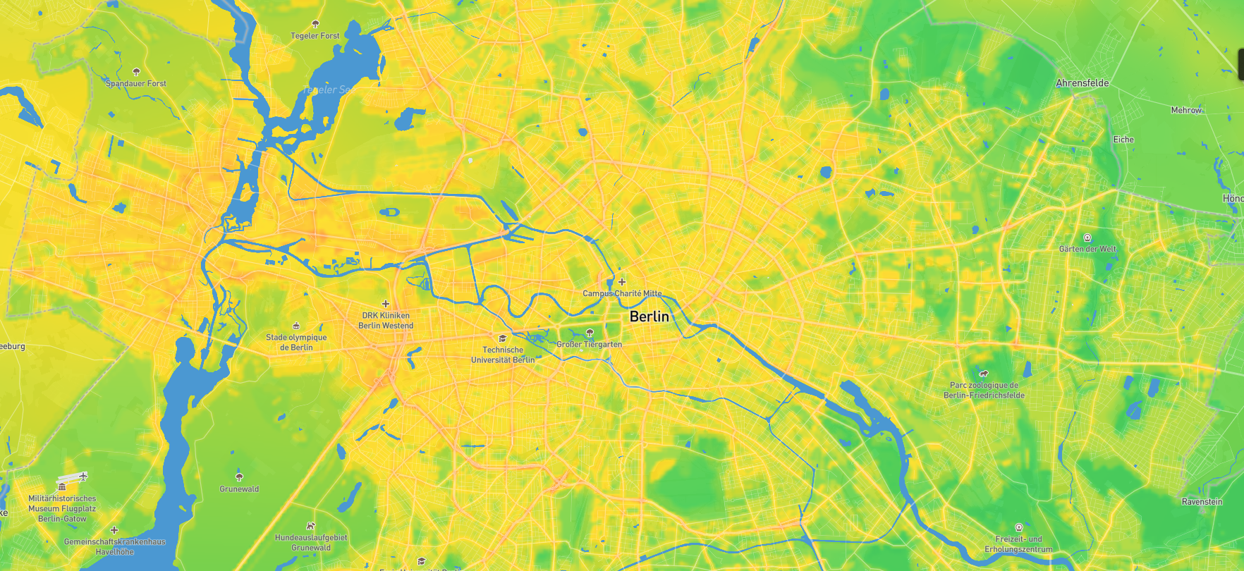
Meersens offers thanks to a geographic server the access to its air quality data. This server follows the rules of the standards OGC (Open Geospatial Consortium) which establish the protocol to access geographical data between a server and a client.
To display the heatmap of a specific pollutant or the index representation of those Meersens deeply recommend the use of WMS (Web Map Service) define by the OGC. WMS specifies different request types:
- GetCapabilities – returns parameters about the WMS server and the available layers
- GetMap – returns a map image. Parameters include: width and height of the map, coordinate reference system, rendering style, image format
- GetFeatureInfo – To request data about a coordinate of the map image.
- DescribeLayer – returns the details of the specified layer requested
Path
import requests

requests.get("https://tiles.meersens.com/wms", headers={
  'apikey': 'your_api_key'
}, params={
  SERVICE: "GetMap",
  VERSION: "1.1.1",
  FORMAT: "image/png",
  TRANSPARENT: true,
  WIDTH: 512,
  HEIGHT: 512,
  SRS: "EPSG:3857",
  tiled: true,
  layers: {layer_name}
})
# With shell, you can just pass the correct header with each request
curl "https://tiles.meersens.com/wms?SERVICE=WMS&VERSION=1.1.1&REQUEST=GetMap&FORMAT=image%2Fpng&TRANSPARENT=true&WIDTH=512&HEIGHT=512&SRS=EPSG%3A3857tiled=true&layers={layer_name}" \
  -H "apikey: your_api_key"
const axios = require('axios');

axios.get("https://tiles.meersens.com/wms",{
  params: {
    SERVICE: "GetMap",
    VERSION: "1.1.1",
    FORMAT: "image/png",
    TRANSPARENT: true,
    WIDTH: 512,
    HEIGHT: 512,
    SRS: "EPSG:3857",
    tiled: true,
    layers: {layer_name}
  }
  headers: {'apikey': 'your_api_key'}
})
GET https://tiles.meersens.com/wms
Example: https://tiles.meersens.com/geowebcache/service/wms?SERVICE=WMS&VERSION=1.1.1&REQUEST=GetMap&FORMAT=image%2Fpng&TRANSPARENT=true&tiled=true&layers=meersens:gam_meersens_2024_04_07_10h00&WIDTH=512&HEIGHT=512&SRS=EPSG%3A3857&BBOX=-2504688.542848654,5009377.085697312,-1252344.271424327,6261721.357121639
Authentication
The Meersens tile server use the same authentication mechanism than 'regular' APIs.
So please request air quality tiles while providing the apikey header filled with your Meersens API key.
Query Parameters
All described parameters below are mandatory.
| Parameter | Type | Description | Value |
|---|---|---|---|
| SERVICE | string | WMS service to consume | GetMap (mandatory) |
| VERSION | string | WMS version to use | 1.1.1 (mandatory) |
| FORMAT | string | Output format of the returned tile | image/png (mandatory) |
| TRANSPARENT | boolean | Transparency of the returned tile | true (mandatory) |
| WIDTH | number | Width (in pixels) of the returned tile | 512 (mandatory) |
| HEIGHT | number | Height (in pixels) of the returned tile | 512 (mandatory) |
| SRS | string | Spatial reference system | EPSG:3857 (mandatory) |
| tiled | boolean | Tile attribute of the returned data | true (mandatory) |
| layers | string | Layer name to request | See data catalog to learn how to construct layer name |
Please note that for now, only 512px x 512px tiles will be returned, projected using EPSG:3857.
Data catalog
Meersens offers multiple layers to display a specific air pollutant or their aggregation with an index/standard. Each hour a new layer is released and can be access to have the current conditions. Meersens also maintain the layers for the last 24 hours conditions. All these information can be accessed thanks to the GetCapabilities URL. Currently the forecast conditions are not exposed on the geographic server, but this subject can be discussed if the need arises.
For each hour, Meersens produces multiple layers, one for each pollutant and one for each standard. The pattern of the layer name is :
meersens:gam_{layer_id}_{YYYY_MM_DD_HHh00}
(e.g meersens:gam_pm25_conc_2024_04_07_18h00, meersens:gam_meersens_2024_04_07_12h00)
The date parameter present in the layer name should be in UTC timezone.
The layer_id parameter can take the following values:
| Layer id | Type | Description |
|---|---|---|
| o3_conc | Pollutant layer | Ozone concentration (µg/m³) layer |
| no2_conc | Pollutant layer | Nitrogen dioxide concentration (µg/m³) layer |
| pm25_conc | Pollutant layer | Particulate matter 2.5 concentration (µg/m³) layer |
| pm10_conc | Pollutant layer | Particulate matter 10 concentration (µg/m³) layer |
| meersens | Index layer | Meersens proprietary Air Quality Index layer |
| cn_aqi | Index layer | China MEP Air Quality Index layer |
| fra_aqi | Index layer | France ATMO Air Quality Index layer |
| usa_aqi | Index layer | US Environmental Protection Agency (EPA) Air Quality Index layer |
Client access
As Meersens follows the OGC and particularly WMS, all the front client library can access the data easily, thus JS clients such as OpenLayers, Leaflet, Mapbox and so on support WMS protocol.
Air quality indexes
In order to let you easily interpretate environmental data, each one is associated to an environmental index. This index is designed to represent a human-readable assessment of a given environmental quality, simplifying the readings of raw pollutants concentrations and emphasizing eventual country specificities given pollutants levels interpretation.
For Air Quality, Meersens currently supports the following indexes:
| ID | Name | Numeric | Description | Pollutants |
|---|---|---|---|---|
| meersens | Meersens Air Quality Index | true | Meersens proprietary Air Quality Index | pm25, pm10, o3, no2, so2 |
| bel_aqi | BE Air Quality Index | true | Belgium BelAQI Air Quality Index | pm25, pm10, o3, no2 |
| bel_aqi2022 | BE Air Quality Index 2022 | true | Belgium BelAQI Air Quality Index 2022 update | pm25, pm10, o3, no2 |
| cn_aqi | CN Air Quality Index | true | China MEP Air Quality Index | pm25, pm10, o3, no2, so2 |
| eu_aqi | EU Air Quality Index | false | European Environmental Agency Air Quality Index | pm25, pm10, o3, no2, so2 |
| fra_aqi | FR Air Quality Index | false | France ATMO Air Quality Index | pm25, pm10, o3, no2, so2 |
| usa_aqi | US Air Quality Index | true | US Environmental Protection Agency (EPA) Air Quality Index | pm25, pm10, o3, no2, so2, co |
| MTEI | Meersens time exposure index 2025 | true | Meersens time exposure index 2025 | pm25, pm10, o3, no2, so2 |
Air quality current conditions
Air quality at location
import requests

requests.get("https://api.meersens.com/environment/public/air/current", headers={
  'apikey': 'your_api_key'
}, params={
  lat: 1.234,
  lng: 5.678
})
# With shell, you can just pass the correct header with each request
curl "https://api.meersens.com/environment/public/air/current?lat=1.234&lng=5.678" \
  -H "apikey: your_api_key"
const axios = require('axios');

axios.get("https://api.meersens.com/environment/public/air/current",{
  params: {
    lat: 1.234,
    lng: 5.678
  }
  headers: {'apikey': 'your_api_key'}
})
The above API returns the following JSON structured response:
{
    "found": true,
    "datetime": "2024-04-07T21:00:00.000Z",
    "index": {
        "index_type": "meersens",
        "index_name": "Meersens",
        "qualification": "Degraded",
        "icon": null,
        "color": "#adc704",
        "value": 34.13,
        "main_pollutants": [
            "pm25"
        ]
    },
    "pollutants": {
        "no2": {
            "shortcode": "NO2",
            "name": "Nitrogen dioxide",
            "unit": "µg/m³",
            "found": true,
            "value": 16.8,
            "confidence": 4.5,
            "index": {
                "index_type": "meersens",
                "index_name": "Meersens",
                "qualification": "Good",
                "icon": null,
                "color": "#05b3a4",
                "description": "That air quality level won’t present a risk for health for an exposure time superior to decades",
                "value": 14.28
            }
        },
        "co": {...},
        "o3": {...},
        "pm10": {...},
        "pm25": {...},
        "so2": {...}
    },
    "health_recommendations": {
        "all": "Degraded air quality can cause irritation of the respiratory tract and cause respiratory discomfort.",
        "family": "Children with an immature respiratory system are more impacted by poor air quality. Outdoor activities can be maintained as long as there is no respiratory or cardiac discomfort.",
        "sport": "Physical activities cause an increase in respiratory rate which leads to increased exposure to pollutants and potentially to symptoms resulting from them.",
        "pregnancy": "Exposure to pollutants can affect the fetus and pregnancy (lower birth weight, preterm delivery ...)",
        "respiratory": "Air pollution can worsen respiratory pathologies such as asthma, COPD, chronic bronchitis ...",
        "elderly": "With age, the respiratory system can become weakened and pollution can exacerbate respiratory problems",
        "cardiovascular": "Air pollution has been implicated in the development or aggravation of cardiovascular disease"
    }
}
Returns current information about air quality conditions for a specific location.
Path
GET https://api.meersens.com/environment/public/air/current
Query Parameters
| Parameter | Type | Description | Required |
|---|---|---|---|
| lat | number | Latitude of the location to compute air quality conditions at. In WGS84 format. | true |
| lng | number | Longitude of the location to compute air quality conditions at. In WGS84 format. | true |
| index_type | string | Unique identifier of the desired output air quality index. Use reserved keyword local to get the locally applicable index at the point you're requesting data. | false (default: meersens) |
| health_recommendations | boolean | Indicates whether health recommendations should be retrieved for this air quality levels or not. | false (default: false) |
Response attributes
| Parameter | Type | Description |
|---|---|---|
| found | boolean | Whether at least one pollutant value has been found. |
| datetime | string | ISO_8601 UTC datetime indicating the time the data refers to. |
| index | object | Air quality index object. |
| index.index_type | string | Unique identifier of the returned air quality index. |
| index.index_name | string | Name of the returned air quality index. |
| index.qualification | string | Air quality index textual representation. |
| index.description | string | Air quality index textual assessment. |
| index.icon | string | Air quality level associated icon (if any, otherwise null). |
| index.color | string | Air quality level hexadecimal color code. |
| index.value | number | Air quality level value (for numeric indexes only, otherwise null). |
| index.main_pollutants | array | Array of main pollutants identifiers. |
| pollutants | object | Dictionary of available pollutants at the requested point. |
| pollutants.shortcode | string | Pollutant textual shortcode. |
| pollutants.name | string | Pollutant full name. |
| pollutants.unit | string | Unit in which the pollutant value is returned. |
| pollutants.found | boolean | Whether the pollutant value has been found. |
| pollutants.value | number | Value of the pollutant in specified unit. |
| pollutants.confidence | number | Pollutant value confidence. |
| pollutants.index | object | Pollutant specific index information |
| pollutants.index.index_type | string | Unique identifier of the returned air quality index. |
| pollutants.index.index_name | string | Name of the returned air quality index. |
| pollutants.index.qualification | string | Air quality index textual representation. |
| pollutants.index.description | string | Air quality index textual assessment. |
| pollutants.index.icon | string | Pollutant level associated icon (if any, otherwise null). |
| pollutants.index.color | string | Pollutant level hexadecimal color code. |
| pollutants.index.value | number | Pollutant level index value (for numeric indexes only, otherwise null). |
| health_recommendations | object | Dictionary of health recommendations for various population categories, including: -all : general population -family : populations with childrens -sport : sports populations -pregnancy : pregnant populations -elderly : elderly populations -respiratory : populations with respiratory diseases -cardiovascular : populations with cardiovascular diseases |
Responses
| HTTP status | Meaning | Notes |
|---|---|---|
| 200 | OK | Response returned |
| 401 | Unauthorized | Something is wrong with your api key. |
| 403 | Forbidden | Either you're requesting an environmental category you do not have access to, or an area outside of your authorized ones. |
| 429 | Too many requests | You are above your calls quota. |
Air quality aggregation
import requests

requests.get("https://api.meersens.com/environment/public/air/current/aggregate", headers={
  'apikey': 'your_api_key'
}, params={
  code: 10001,
  location_type: 'ZIP5',
  iso2_code: 'US'
})
# With shell, you can just pass the correct header with each request
curl "https://api.meersens.com/environment/public/air/current/aggregate?code=10001&location_type=zip5&iso2_code=use" \
  -H "apikey: your_api_key"
const axios = require('axios');

axios.get("https://api.meersens.com/environment/public/air/current/aggregate",{
  params: {
    code: 10001,
    location_type: 'ZIP5',
    iso2_code: 'US'
  }
  headers: {'apikey': 'your_api_key'}
})
The above API returns the following JSON structured response:
{
    "found": true,
    "datetime": "2024-04-07",
    "indexes": {
        "mean": {
            "index_type": "meersens",
            "index_name": "MAQI",
            "qualification": "Moderate",
            "icon": null,
            "color": "#adc704",
            "description": "Air quality level will present a risk for health for an exposure time superior to several days",
            "value": 40.95,
            "main_pollutants": [
                "o3"
            ]
        },
        "min": {
            "index_type": "meersens",
            "index_name": "MAQI",
            "qualification": "Moderate",
            "icon": null,
            "color": "#adc704",
            "description": "Air quality level will present a risk for health for an exposure time superior to several days",
            "value": 40.05,
            "main_pollutants": [
                "o3"
            ]
        },
        "max": {
            "index_type": "meersens",
            "index_name": "MAQI",
            "qualification": "Moderate",
            "icon": null,
            "color": "#adc704",
            "description": "Air quality level will present a risk for health for an exposure time superior to several days",
            "value": 47.73,
            "main_pollutants": [
                "no2"
            ]
        }
    },
    "pollutants": {
        "co": {
            "shortcode": "CO",
            "name": "Carbon monoxide",
            "unit": "µg/m³",
            "found": true,
            "values": {
                "mean": 135,
                "min": 133.4,
                "max": 136.4
            },
            "confidence": 5,
            "indexes": {
                "mean": {
                    "index_type": "meersens",
                    "index_name": "MAQI",
                    "qualification": "Good",
                    "icon": null,
                    "color": "#05b3a4",
                    "description": "Air quality level won’t present a risk for health for an exposure time superior to decades",
                    "value": 0.33
                },
                "min": {
                    "index_type": "meersens",
                    "index_name": "MAQI",
                    "qualification": "Good",
                    "icon": null,
                    "color": "#05b3a4",
                    "description": "Air quality level won’t present a risk for health for an exposure time superior to decades",
                    "value": 0.32
                },
                "max": {
                    "index_type": "meersens",
                    "index_name": "MAQI",
                    "qualification": "Good",
                    "icon": null,
                    "color": "#05b3a4",
                    "description": "Air quality level won’t present a risk for health for an exposure time superior to decades",
                    "value": 0.33
                }
            }
        },
        "no2": {...},
        "o3": {...},
        "pm10": {...},
        "pm25": {...},
        "so2": {...}
      }
    }
}
Returns current information about air quality conditions for a given geographic code. The returned results give an overview of the minimum, maximum and average values found for each pollutant, on the area covered by the specified geographic code. Please note that this is only available for US ZIP codes so far.
Path
GET https://api.meersens.com/environment/public/air/current/aggregate
Query Parameters
| Parameter | Type | Description | Required |
|---|---|---|---|
| location_type | string | The type of the location to apply the aggregation on (point, ZIP5). | true |
| lat | number | Latitude of the location to compute air conditions at. In WGS84 format. Required if location_type = "point". | false |
| lng | number | Longitude of the location to compute air conditions at. In WGS84 format. Required if location_type = "point". | false |
| code | number | The code of the geographical area to aggregate. Required if location_type is not "point". | false |
| iso2_code | string | The ISO 3166-1 alpha-2 code of the country of the requested administrative code. Required if location_type is not "point". | false |
| index_type | string | Unique identifier of the desired output air quality index. Use reserved keyword local to get the locally applicable index at the area you're requesting data. | false (default: meersens) |
Response attributes
| Parameter | Type | Description |
|---|---|---|
| found | boolean | Whether at least one pollutant value has been found. |
| datetime | string | ISO_8601 UTC datetime indicating the day the data refers to. |
| indexes | object | Dictionary of the min, max and mean air quality index objects. |
| indexes.[statistic].index_type | string | Unique identifier of the returned air quality index. |
| indexes.[statistic].index_name | string | Name of the returned air quality index. |
| indexes.[statistic].qualification | string | Air quality index textual representation. |
| indexes.[statistic].description | string | Air quality index textual assessment. |
| indexes.[statistic].icon | string | Air quality level associated icon (if any, otherwise null). |
| indexes.[statistic].color | string | Air quality level hexadecimal color code. |
| indexes.[statistic].value | number | Air quality level value (for numeric indexes only, otherwise null). |
| indexes.[statistic].main_pollutants | array | Array of main pollutants identifiers. |
| pollutants | object | Dictionary of available pollutants at the requested point. |
| pollutants.shortcode | string | Pollutant textual shortcode. |
| pollutants.name | string | Pollutant full name. |
| pollutants.unit | string | Unit in which the pollutant value is returned. |
| pollutants.found | boolean | Whether the pollutant value has been found. |
| pollutants.values | object | Dictionary of the pollutant values statistics in specified unit. |
| pollutants.values.min | number | Minimum value of the pollutant in specified unit on the requested area. |
| pollutants.values.max | number | Maximum value of the pollutant in specified unit on the requested area. |
| pollutants.values.mean | number | Average value of the pollutant in specified unit on the requested area. |
| pollutants.confidence | number | Pollutant value confidence. |
| pollutants.indexes | object | Dictionary of the pollutant specific index information statistics over the requested area. |
| pollutants.indexes.[statistic].index_type | string | Unique identifier of the returned air quality index. |
| pollutants.indexes.[statistic].index_name | string | Name of the returned air quality index. |
| pollutants.indexes.[statistic].qualification | string | Air quality index textual representation. |
| pollutants.indexes.[statistic].description | string | Air quality index textual assessment. |
| pollutants.indexes.[statistic].icon | string | Pollutant level associated icon (if any, otherwise null). |
| pollutants.indexes.[statistic].color | string | Pollutant level hexadecimal color code. |
| pollutants.indexes.[statistic].value | number | Pollutant level index value (for numeric indexes only, otherwise null). |
| health_recommendations | object | Dictionary of health recommendations computed for various population categories, including: -all : general population -family : populations with childrens -sport : sports populations -pregnancy : pregnant populations -elderly : elderly populations -respiratory : populations with respiratory diseases -cardiovascular : populations with cardiovascular diseases The health recommendations are computed using the mean values of the current conditions over the specified area. |
Responses
| HTTP status | Meaning | Notes |
|---|---|---|
| 200 | OK | Response returned |
| 401 | Unauthorized | Something is wrong with your api key. |
| 403 | Forbidden | Either you're requesting an environmental category you do not have access to, or an area outside of your authorized ones. |
| 429 | Too many requests | You are above your calls quota. |
| 500 | Internal server error | Something went wrong on our side. If the issue persists, please contact us with relevant details. |
Air quality history
Air quality at location
import requests

requests.get("https://api.meersens.com/environment/public/air/history", headers={
  'apikey': 'your_api_key'
}, params={
  lat: 1.234,
  lng: 5.678,
  from: '2024-01-01T00:00:00Z',
  to: '2024-01-02T00:00:00Z',
  page: 0
})
# With shell, you can just pass the correct header with each request
curl "https://api.meersens.com/environment/public/air/history?lat=1.234&lng=5.678&from=2024-01-01T00:00:00Z&to=2024-01-02T00:00:00Z&page=0" \
  -H "apikey: your_api_key"
const axios = require('axios');

axios.get("https://api.meersens.com/environment/public/air/forecast",{
  params: {
    lat: 1.234,
    lng: 5.678,
    from: '2024-01-01T00:00:00Z',
    to: '2024-01-02T00:00:00Z',
    page: 0
  }
  headers: {'apikey': 'your_api_key'}
})
The above API returns the following JSON structured response:
{
    "found": true,
    "values": [
        {
            "datetime": "2024-04-01T22:00:00.000Z",
            "pollutants": {
                "no2": {
                    "found": true,
                    "name": "Nitrogen dioxide",
                    "shortcode": "NO2",
                    "unit": "µg/m³",
                    "value": 11.3,
                    "confidence": 4.5,
                    "index": {
                        "index_type": "meersens",
                        "index_name": "Meersens",
                        "qualification": "Good",
                        "icon": null,
                        "color": "#05b3a4",
                        "description": "That air quality level won’t present a risk for health for an exposure time superior to decades",
                        "value": 9.61
                    }
                },
                "co": {...},
                "o3": {...},
                "pm10": {...},
                "pm25": {...},
                "so2": {...}
            },
            "index": {
                "index_type": "meersens",
                "index_name": "Meersens",
                "qualification": "Correct",
                "icon": null,
                "color": "#44b001",
                "value": 32.62,
                "main_pollutants": [
                    "o3"
                ]
            },
            "found": true
        },
        {...}
    ],
    "page": {
        "totalElements": 24,
        "totalPages": 4,
        "pageNumber": 0,
        "size": 6
    }
}
Returns paginated hourly history air quality data at a given location. For each hour included in the requested timeframe, the pollutants concentrations will be retrieved (if found), along with the computed air quality index. Each returned page will contain up to 6 time points entries.
Path
GET https://api.meersens.com/environment/public/air/history
Query Parameters
| Parameter | Type | Description | Required |
|---|---|---|---|
| lat | number | Latitude of the location to compute air quality conditions at. In WGS84 format. | true |
| lng | number | Longitude of the location to compute air quality conditions at. In WGS84 format. | true |
| from | string | ISO_8601 UTC datetime (including timezone) that indicates the starting date of the history timeframe data. | false (default: 24 hours ago) |
| to | string | ISO_8601 UTC datetime (including timezone) that indicates the ending date of the history timeframe data. | false (default: beginning of current hour) |
| index_type | string | Unique identifier of the desired output air quality index. Use reserved keyword local to get the locally applicable index at the point you're requesting data. | false (default: meersens) |
| page | number | The number of the page to return among the pages of results. | false (default: 0) |
Response attributes
| Parameter | Type | Description |
|---|---|---|
| found | boolean | Whether at least one pollutant value has been found over the period. |
| values | array | Array of hourly air quality values. |
| values.datetime | string | ISO_8601 UTC datetime indicating the time the data refers to for this hourly entry. |
| values.index | object | Air quality index object for this hourly entry. |
| values.index.index_type | string | Unique identifier of the returned air quality index. |
| values.index.index_name | string | Name of the returned air quality index. |
| values.index.qualification | string | Air quality index textual representation. |
| values.index.description | string | Air quality index textual assessment. |
| values.index.icon | string | Air quality level associated icon (if any, otherwise null). |
| values.index.color | string | Air quality level hexadecimal color code. |
| values.index.value | number | Air quality level value (for numeric indexes only, otherwise null). |
| values.index.main_pollutants | array | Array of main pollutants identifiers. |
| values.pollutants | object | Dictionary of available pollutants at the requested point for this hourly entry. |
| values.pollutants.shortcode | string | Pollutant textual shortcode. |
| values.pollutants.name | string | Pollutant full name. |
| values.pollutants.unit | string | Unit in which the pollutant value is returned. |
| values.pollutants.found | boolean | Whether the pollutant value has been found. |
| values.pollutants.value | number | Value of the pollutant in specified unit. |
| values.pollutants.confidence | number | Pollutant value confidence. |
| values.pollutants.index | object | Pollutant specific index information |
| values.pollutants.index.index_type | string | Unique identifier of the returned air quality index. |
| values.pollutants.index.index_name | string | Name of the returned air quality index. |
| values.pollutants.index.qualification | string | Air quality index textual representation. |
| values.pollutants.index.description | string | Air quality index textual assessment. |
| values.pollutants.index.icon | string | Pollutant level associated icon (if any, otherwise null). |
| values.pollutants.index.color | string | Pollutant level hexadecimal color code. |
| values.pollutants.index.value | number | Pollutant level index value (for numeric indexes only, otherwise null). |
| page | object | Object containing information about the pagination of the response. |
| page.totalElements | number | The total amount of air quality values. |
| page.totalPages | number | The amount of pages of air quality values. |
| page.pageNumber | number | The number of the page currently returned. |
| page.size | number | The amount of air quality values returned per page. |
Responses
| HTTP status | Meaning | Notes |
|---|---|---|
| 200 | OK | Response returned |
| 401 | Unauthorized | Something is wrong with your api key. |
| 403 | Forbidden | Either you're requesting an environmental category you do not have access to, or an area outside of your authorized ones. |
| 429 | Too many requests | You are above your calls quota. |
Air quality aggregation
import requests

requests.get("https://api.meersens.com/environment/public/air/history/aggregate", headers={
  'apikey': 'your_api_key'
}, params={
  code: 69006,
  location_type: 'ZIP5',
  iso2_code: 'US',
  page: 1,
  from: '2024-04-01T00:00:00Z',
  to: '2024-04-05T00:00:00Z'
})
# With shell, you can just pass the correct header with each request
curl "https://api.meersens.com/environment/public/air/history/aggregate?code=10001&location_type=zip5&iso2_code=us&page=1&from=2024-04-01T00:00:00Z&to=2024-01-05T00:00:00Z" \
  -H "apikey: your_api_key"
const axios = require('axios');

axios.get("https://api.meersens.com/environment/public/air/history/aggregate",{
  params: {
    code: 69006,
    location_type: 'ZIP5',
    iso2_code: 'US',
    page: 1,
    from: '2024-04-01T00:00:00Z',
    to: '2024-04-05T00:00:00Z'
  }
  headers: {'apikey': 'your_api_key'}
})
The above API returns the following JSON structured response:
{
    "found": true,
    "values": [
        {
            "datetime": "2024-03-01",
            "found": true,
            "pollutants": {
                "co": {
                    "id": "co",
                    "shortcode": "CO",
                    "name": "Carbon monoxide",
                    "unit": "µg/m³",
                    "found": true,
                    "values": {
                        "mean": 255.1,
                        "min": 217.1,
                        "max": 340.3
                    },
                    "confidence": 5,
                    "standards": {
                        "mean": {
                            "index_type": "meersens",
                            "index_name": "MAQI",
                            "qualification": "Perfect",
                            "icon": null,
                            "safe": true,
                            "color": "#066b78",
                            "description": "Air quality level won’t present a risk for health for an exposure time superior to decades",
                            "discrete": false,
                            "risk": 0.62,
                            "class": 0
                        },
                        "min": {
                            "index_type": "meersens",
                            "index_name": "MAQI",
                            "qualification": "Perfect",
                            "icon": null,
                            "safe": true,
                            "color": "#066b78",
                            "description": "Air quality level won’t present a risk for health for an exposure time superior to decades",
                            "discrete": false,
                            "risk": 0.53,
                            "class": 0
                        },
                        "max": {
                            "index_type": "meersens",
                            "index_name": "MAQI",
                            "qualification": "Perfect",
                            "icon": null,
                            "safe": true,
                            "color": "#066b78",
                            "description": "Air quality level won’t present a risk for health for an exposure time superior to decades",
                            "discrete": false,
                            "risk": 0.83,
                            "class": 0
                        }
                    }
                },
                "no2": {...},
                "o3": {...},
                "pm10": {...},
                "pm25": {...},
                "so2": {...}
            },
            "indexes": {
                "mean": {
                    "index_type": "meersens",
                    "index_name": "MAQI",
                    "qualification": "Medium",
                    "icon": null,
                    "safe": false,
                    "color": "#ff851b",
                    "description": "Air quality level will present a risk for health for an exposure time superior to some hours",
                    "risk": 52.53,
                    "discrete": false,
                    "main_pollutants": [
                        "no2"
                    ]
                },
                "min": {
                    "index_type": "meersens",
                    "index_name": "MAQI",
                    "qualification": "Medium",
                    "icon": null,
                    "safe": false,
                    "color": "#ff851b",
                    "description": "Air quality level will present a risk for health for an exposure time superior to some hours",
                    "risk": 50.84,
                    "discrete": false,
                    "main_pollutants": [
                        "no2"
                    ]
                },
                "max": {
                    "index_type": "meersens",
                    "index_name": "MAQI",
                    "qualification": "Medium",
                    "icon": null,
                    "safe": false,
                    "color": "#ff851b",
                    "description": "Air quality level will present a risk for health for an exposure time superior to some hours",
                    "risk": 55.14,
                    "discrete": false,
                    "main_pollutants": [
                        "no2"
                    ]
                }
            }
        },
        {...}
    ],
    "page": {
        "totalElements": 4,
        "totalPages": 1,
        "pageNumber": 0,
        "size": 6
    }
}
Returns daily history air quality data for a given area or location. For each day included in the requested timeframe, the minimum, maximum and average pollutants concentrations will be retrieved (if found), along with the computed min, max and mean air quality indexes. Please note that this is only available for US ZIP codes so far.
Path
GET https://api.meersens.com/environment/public/air/history/aggregate
Query Parameters
| Parameter | Type | Description | Required |
|---|---|---|---|
| location_type | string | The type of requested location ("point" or "ZIP5"). | true |
| code | number | The code of the geographical area to aggregate. Required if location_type is not "point" | false |
| iso2_code | string | The ISO 3166-1 alpha-2 code of the country of the requested code. Required if location_type is not "point" | false |
| lat | number | The latitude of the point to request daily values for. Required if location_type = "point". | false |
| lng | number | The longitude of the point to request daily values for. Required if location_type = "point". | false |
| from | string | ISO_8601 datetime (timezone indifferent) that indicates the starting date of the history timeframe data. Daily data is returned using local timezone of the requested area. | false (default: beginning of previous day) |
| to | string | ISO_8601 datetime (timezone indifferent) that indicates the ending date of the history timeframe data. | false (default: beginning of current day) |
| page | number | The number of the page to return among the pages of results. | false (default: 0) |
| index_type | string | Unique identifier of the desired output air quality index. Use reserved keyword local to get the locally applicable index at the area you're requesting data. | false (default: meersens) |
Response attributes
| Parameter | Type | Description |
|---|---|---|
| found | boolean | Whether at least one pollutant value has been found. |
| values | array | Array of daily air quality min, max and mean values. |
| values.datetime | string | ISO_8601 UTC datetime indicating the day the data refers to for this daily entry. |
| values.indexes | object | Dictionary of the min, max and mean air quality index objects. |
| values.indexes.[statistic].index_type | string | Unique identifier of the returned air quality index. |
| values.indexes.[statistic].index_name | string | Name of the returned air quality index. |
| values.indexes.[statistic].qualification | string | Air quality index textual representation. |
| values.indexes.[statistic].description | string | Air quality index textual assessment. |
| values.indexes.[statistic].icon | string | Air quality level associated icon (if any, otherwise null). |
| values.indexes.[statistic].color | string | Air quality level hexadecimal color code. |
| values.indexes.[statistic].value | number | Air quality level value (for numeric indexes only, otherwise null). |
| values.indexes.[statistic].main_pollutants | array | Array of main pollutants identifiers. |
| values.pollutants | object | Dictionary of available pollutants at the requested point. |
| values.pollutants.shortcode | string | Pollutant textual shortcode. |
| values.pollutants.name | string | Pollutant full name. |
| values.pollutants.unit | string | Unit in which the pollutant value is returned. |
| values.pollutants.found | boolean | Whether the pollutant value has been found. |
| values.pollutants.values | object | Dictionary of the pollutant values statistics in specified unit. |
| values.pollutants.values.min | number | Minimum value of the pollutant in specified unit on the requested area. |
| values.pollutants.values.max | number | Maximum value of the pollutant in specified unit on the requested area. |
| values.pollutants.values.mean | number | Average value of the pollutant in specified unit on the requested area. |
| values.pollutants.confidence | number | Pollutant value confidence. |
| values.pollutants.indexes | object | Dictionary of the pollutant specific index information statistics over the requested area. |
| values.pollutants.indexes.[statistic].index_type | string | Unique identifier of the returned air quality index. |
| values.pollutants.indexes.[statistic].index_name | string | Name of the returned air quality index. |
| values.pollutants.indexes.[statistic].qualification | string | Air quality index textual representation. |
| values.pollutants.indexes.[statistic].description | string | Air quality index textual assessment. |
| values.pollutants.indexes.[statistic].icon | string | Pollutant level associated icon (if any, otherwise null). |
| values.pollutants.indexes.[statistic].color | string | Pollutant level hexadecimal color code. |
| values.pollutants.indexes.[statistic].value | number | Pollutant level index value (for numeric indexes only, otherwise null). |
| page | object | Object containing information about the pagination of the response. |
| page.totalElements | number | The total amount of air quality values. |
| page.totalPages | number | The amount of pages of air quality values. |
| page.pageNumber | number | The number of the page currently returned. |
| page.size | number | The amount of air quality values returned per page. |
Responses
| HTTP status | Meaning | Notes |
|---|---|---|
| 200 | OK | Response returned |
| 401 | Unauthorized | Something is wrong with your api key. |
| 403 | Forbidden | Either you're requesting an environmental category you do not have access to, or an area outside of your authorized ones. |
| 429 | Too many requests | You are above your calls quota. |
| 500 | Internal server error | Something went wrong on our side. If the issue persists, please contact us with relevant details. |
Air quality forecast
Air quality at location
import requests

requests.get("https://api.meersens.com/environment/public/air/forecast", headers={
  'apikey': 'your_api_key'
}, params={
  lat: 1.234,
  lng: 5.678,
  from: '2024-01-01T00:00:00Z',
  to: '2024-01-02T00:00:00Z',
  page: 0
})
# With shell, you can just pass the correct header with each request
curl "https://api.meersens.com/environment/public/air/forecast?lat=1.234&lng=5.678&from=2024-01-01T00:00:00Z&to=2024-01-02T00:00:00Z&page=0" \
  -H "apikey: your_api_key"
const axios = require('axios');

axios.get("https://api.meersens.com/environment/public/air/forecast",{
  params: {
    lat: 1.234,
    lng: 5.678,
    from: '2024-01-01T00:00:00Z',
    to: '2024-01-02T00:00:00Z',
    page: 0
  }
  headers: {'apikey': 'your_api_key'}
})
The above API returns the following JSON structured response:
{
    "found": true,
    "values": [
        {
            "datetime": "2024-04-01T22:00:00.000Z",
            "pollutants": {
                "no2": {
                    "found": true,
                    "name": "Nitrogen dioxide",
                    "shortcode": "NO2",
                    "unit": "µg/m³",
                    "value": 11.3,
                    "confidence": 4.5,
                    "index": {
                        "index_type": "meersens",
                        "index_name": "Meersens",
                        "qualification": "Good",
                        "icon": null,
                        "color": "#05b3a4",
                        "description": "That air quality level won’t present a risk for health for an exposure time superior to decades",
                        "value": 9.61
                    }
                },
                "co": {...},
                "o3": {...},
                "pm10": {...},
                "pm25": {...},
                "so2": {...}
            },
            "index": {
                "index_type": "meersens",
                "index_name": "Meersens",
                "qualification": "Correct",
                "icon": null,
                "color": "#44b001",
                "value": 32.62,
                "main_pollutants": [
                    "o3"
                ]
            },
            "found": true
        },
        {...}
    ],
    "page": {
        "totalElements": 24,
        "totalPages": 2,
        "pageNumber": 0,
        "size": 6
    }
}
Returns paginated hourly forecast air quality data at a given location. For each hour included in the requested timeframe, the pollutants concentrations will be retrieved (if found), along with the computed air quality index. The maximum timeframe allowed to be requested is 96 hours, meaning 4 days. Each returned page will contain up to 6 time points entries.
Path
GET https://api.meersens.com/environment/public/air/forecast
Query Parameters
| Parameter | Type | Description | Required |
|---|---|---|---|
| lat | number | Latitude of the location to compute air quality conditions at. In WGS84 format. | true |
| lng | number | Longitude of the location to compute air quality conditions at. In WGS84 format. | true |
| from | string | ISO_8601 UTC datetime (including timezone) that indicates the starting date of the forecast timeframe data. | false (default: beginning of current hour) |
| to | string | ISO_8601 UTC datetime (including timezone) that indicates the ending date of the forecast timeframe data. | false (default: 24 hours from now) |
| index_type | string | Unique identifier of the desired output air quality index. Use reserved keyword local to get the locally applicable index at the point you're requesting data. | false (default: meersens) |
| page | number | The number of the page to return among the pages of results. | false (default: 0) |
Response attributes
| Parameter | Type | Description |
|---|---|---|
| found | boolean | Whether at least one pollutant value has been found over the period. |
| values | array | Array of hourly air quality values. |
| values.datetime | string | ISO_8601 UTC datetime indicating the time the data refers to for this hourly entry. |
| values.index | object | Air quality index object for this hourly entry. |
| values.index.index_type | string | Unique identifier of the returned air quality index. |
| values.index.index_name | string | Name of the returned air quality index. |
| values.index.qualification | string | Air quality index textual representation. |
| values.index.description | string | Air quality index textual assessment. |
| values.index.icon | string | Air quality level associated icon (if any, otherwise null). |
| values.index.color | string | Air quality level hexadecimal color code. |
| values.index.value | number | Air quality level value (for numeric indexes only, otherwise null). |
| values.index.main_pollutants | array | Array of main pollutants identifiers. |
| values.pollutants | object | Dictionary of available pollutants at the requested point for this hourly entry. |
| values.pollutants.shortcode | string | Pollutant textual shortcode. |
| values.pollutants.name | string | Pollutant full name. |
| values.pollutants.unit | string | Unit in which the pollutant value is returned. |
| values.pollutants.found | boolean | Whether the pollutant value has been found. |
| values.pollutants.value | number | Value of the pollutant in specified unit. |
| values.pollutants.confidence | number | Pollutant value confidence. |
| values.pollutants.index | object | Pollutant specific index information |
| values.pollutants.index.index_type | string | Unique identifier of the returned air quality index. |
| values.pollutants.index.index_name | string | Name of the returned air quality index. |
| values.pollutants.index.qualification | string | Air quality index textual representation. |
| values.pollutants.index.description | string | Air quality index textual assessment. |
| values.pollutants.index.icon | string | Pollutant level associated icon (if any, otherwise null). |
| values.pollutants.index.color | string | Pollutant level hexadecimal color code. |
| values.pollutants.index.value | number | Pollutant level index value (for numeric indexes only, otherwise null). |
| page.totalElements | number | The total amount of air quality values. |
| page.totalPages | number | The amount of pages of air quality values. |
| page.pageNumber | number | The number of the page currently returned. |
| page.size | number | The amount of air quality values returned per page. |
Responses
| HTTP status | Meaning | Notes |
|---|---|---|
| 200 | OK | Response returned |
| 401 | Unauthorized | Something is wrong with your api key. |
| 403 | Forbidden | Either you're requesting an environmental category you do not have access to, or an area outside of your authorized ones. |
| 429 | Too many requests | You are above your calls quota. |
Air quality aggregation
Returns daily forecast air quality data at a given location. For each day included in the requested timeframe, the minimum, maximum and average pollutants concentrations will be retrieved (if found), along with the computed min, max and mean air quality indexes. The maximum timeframe allowed to be requested is 2 days. Please refer to the history aggregation for details about the query input and output. Please note that this is only available for US ZIP codes so far.
Path
GET https://api.meersens.com/environment/public/air/forecast/aggregate
Air monthly
Air at location
import requests

requests.get("https://api.meersens.com/environment/public/air/monthly", headers={
  'apikey': 'your_api_key'
}, params={
  lat: 45.7,
  lng: 4.8,
  from: '2026-04-01',
  to: '2026-06-01'
})
curl "https://api.meersens.com/environment/public/air/monthly?lat=45.7&lng=4.8&from=2026-04-01&to=2026-06-01" \
  -H "apikey: your_api_key"
const axios = require('axios');

axios.get("https://api.meersens.com/environment/air/air/monthly",{
  params: {
    lat: 45.7,
    lng: 4.8,
    from: '2026-04-01',
    to: '2026-06-01'
  },
  headers: {'apikey': 'your_api_key'}
})
The above API returns the following JSON structured response:
{
   "found":true,
   "values":[
      {
         "datetime":"2026-04",
         "found":true,
         "pollutants":{
            "co":{
               "shortcode":"CO",
               "name":"Monoxyde de carbone",
               "unit":"µg/m³",
               "found":true,
               "values":{
                  "mean":169.55340576171875,
                  "min":115.21099853515625,
                  "max":251.87899780273438,
                  "avg_max":202.30340576171875,
                  "avg_min":149.57736206054688
               },
               "standards":{
                  "mean":{
                     "index_type":"usa_aqi",
                     "index_name":"US AQI",
                     "qualification":"Bon",
                     "icon":null,
                     "safe":true,
                     "color":"#00e400",
                     "description":"La qualité de l'air est jugée satisfaisante, et la pollution atmosphérique ne présente que peu ou pas de risques.",
                     "discrete":false,
                     "risk":1.51,
                     "class":0
                  },
                  "min":{
                     "index_type":"usa_aqi",
                     "index_name":"US AQI",
                     "qualification":"Bon",
                     "icon":null,
                     "safe":true,
                     "color":"#00e400",
                     "description":"La qualité de l'air est jugée satisfaisante, et la pollution atmosphérique ne présente que peu ou pas de risques.",
                     "discrete":false,
                     "risk":1.03,
                     "class":0
                  },
                  "max":{
                     "index_type":"usa_aqi",
                     "index_name":"US AQI",
                     "qualification":"Bon",
                     "icon":null,
                     "safe":true,
                     "color":"#00e400",
                     "description":"La qualité de l'air est jugée satisfaisante, et la pollution atmosphérique ne présente que peu ou pas de risques.",
                     "discrete":false,
                     "risk":2.24,
                     "class":0
                  }
               },
               "confidence":2.5,
               "index":null
            },
            "no2":{...},
            "o3":{...},
            "pm10":{...},
            "pm25":{...},
            "so2":{...},
         "indexes":{
            "mean":{
               "index_type":"usa_aqi",
               "index_name":"US AQI",
               "qualification":"Modéré",
               "icon":null,
               "safe":true,
               "color":"#ffff00",
               "description":"Air quality is acceptable",
               "risk":50.32,
               "discrete":false,
               "main_pollutants":[
                  "pm25"
               ]
            },
            "min":{
               "index_type":"usa_aqi",
               "index_name":"US AQI",
               "qualification":"Bon",
               "icon":null,
               "safe":true,
               "color":"#00e400",
               "description":"La qualité de l'air est jugée satisfaisante, et la pollution atmosphérique ne présente que peu ou pas de risques.",
               "risk":20.84,
               "discrete":false,
               "main_pollutants":[
                  "pm25"
               ]
            },
            "max":{
               "index_type":"usa_aqi",
               "index_name":"US AQI",
               "qualification":"Malsain pour les groupes sensibles",
               "icon":null,
               "safe":false,
               "color":"#ff7e00",
               "description":"Les membres des groupes sensibles peuvent ressentir des effets sur la sant�. Le grand public n'est pas susceptible d'�tre affect�.",
               "risk":113.25,
               "discrete":false,
               "main_pollutants":[
                  "o3"
               ]
            },
            "complex":{
               "index_type":"usa_aqi",
               "index_name":"US AQI",
               "qualification":"Modéré",
               "icon":null,
               "safe":true,
               "color":"#ffff00",
               "description":"Air quality is acceptable",
               "risk":50.32,
               "discrete":false,
               "main_pollutants":[
                  "pm25"
               ]
            }
         },
         "index":null
      },
      {
         "datetime":"2026-05",
         "found":true,
     ...
      },
      ...
   ],
   "page":{"totalElements":3,"totalPages":1,"pageNumber":0,"size":6}
}
Returns monthly aggregated air data for a given location. For each month included in the requested timeframe, monthly aggregated air concentrations are computed along with the associated AQI index.
Path
GET https://api.meersens.com/environment/public/air/monthly
Query Parameters
| Parameter | Type | Description | Required |
|---|---|---|---|
| lat | number | Latitude in WGS84 format. | true |
| lng | number | Longitude in WGS84 format. | true |
| from | string | Start date of the requested period in YYYY-MM-DD format. | true |
| to | string | End date of the requested period in YYYY-MM-DD format. | true |
| index_type | string | Desired air index identifier. | false |
Noise
The noise API lets you request noise levels for a specific location. Retrieved information includes average noise levels, data confidence, comparison with W.H.O applicable standards & norms and generic health recommendations.
As the computing of hourly noise levels is not yet possible, this API will retrieve for a specific location average noise levels, based on four different periods of time:
- Ld (Lday): average level of noise for the day period, meaning from 6AM to 6PM
- Le (Levening): average level of noise for the evening period, meaning from 6PM to 10PM
- Ln (Lnight): average level of noise for the night period, meaning from 10PM to 6AM
- Lden (Lday-evening-night): overall average level of noise during a day, used to qualify the annoyance linked to noise exposure. It is calculated from the “Lday”, “Levening”, “Lnight” indicators, sound levels averaged over the periods 6AM-6PM, 6PM-10PM and 10PM-6AM. In addition, a weighting of +5 dB is applied to the evening period and +10 dB to the night period, to take into account that we are more sensitive to noise during these periods.
Noise indexes
In order to let you easily interpretate environmental data, each one is associated to an environmental index. This index is designed to represent a human-readable assessment of a given environmental quality, simplifying the readings of raw pollutants concentrations and emphasizing eventual country specificities given pollutants levels interpretation.
For Noise, Meersens currently supports the following indexes:
| ID | Name | Numeric | Description | Pollutants |
|---|---|---|---|---|
| meersens | Meersens Noise Index | true | Meersens proprietary Noise Index | noise |
Noise current conditions
import requests

requests.get("https://api.meersens.com/environment/public/noise/current", headers={
  'apikey': 'your_api_key'
}, params={
  lat: 1.234,
  lng: 5.678
})
# With shell, you can just pass the correct header with each request
curl "https://api.meersens.com/environment/public/noise/current?lat=1.234&lng=5.678" \
  -H "apikey: your_api_key"
const axios = require('axios');

axios.get("https://api.meersens.com/environment/public/noise/current",{
  params: {
    lat: 1.234,
    lng: 5.678
  }
  headers: {'apikey': 'your_api_key'}
})
The above API returns the following JSON structured response:
{
    "found": true,
    "datetime": "2024-04-07T21:00:00.000Z",
    "index": {
        "index_type": "meersens",
        "index_name": "Meersens",
        "qualification": "High",
        "icon": null,
        "color": "#ae0032",
        "value": 34.13,
        "main_pollutants": [
            "noise"
        ]
    },
    "pollutants": {
        "noise": {
            "shortcode": "Noise",
            "name": "Noise",
            "unit": "dB",
            "found": true,
            "value": 75,
            "confidence": 4.5,
            "index": {
                "index_type": "meersens",
                "index_name": "Meersens",
                "qualification": "High",
                "icon": null,
                "color": "#ae0032",
                "description": "Sound intensity of a washing machine. Noisy.",
                "value": 14.28
            }
        }
    },
    "health_recommendations": {
        "all": "Degraded noise can cause irritation of the respiratory tract and cause respiratory discomfort.",
        "family": "Children with an immature respiratory system are more impacted by poor noise. Outdoor activities can be maintained as long as there is no respiratory or cardiac discomfort.",
        "sport": "Physical activities cause an increase in respiratory rate which leads to increased exposure to pollutants and potentially to symptoms resulting from them.",
        "pregnancy": "Exposure to pollutants can affect the fetus and pregnancy (lower birth weight, preterm delivery ...)",
        "respiratory": "Air pollution can worsen respiratory pathologies such as asthma, COPD, chronic bronchitis ...",
        "elderly": "With age, the respiratory system can become weakened and pollution can exacerbate respiratory problems",
        "cardiovascular": "Air pollution has been implicated in the development or aggravation of cardiovascular disease"
    }
}
Returns current information about noise conditions for a specific location.
Path
GET https://api.meersens.com/environment/public/noise/current
Query Parameters
| Parameter | Type | Description | Required |
|---|---|---|---|
| lat | number | Latitude of the location to compute noise conditions at. In WGS84 format. | true |
| lng | number | Longitude of the location to compute noise conditions at. In WGS84 format. | true |
| index_type | string | Unique identifier of the desired output noise index. Use reserved keyword local to get the locally applicable index at the point you're requesting data. | false (default: meersens) |
| health_recommendations | boolean | Indicates whether health recommendations should be retrieved for this noise levels or not. | false (default: false) |
Response attributes
| Parameter | Type | Description |
|---|---|---|
| found | boolean | Whether at least one pollutant value has been found. |
| datetime | string | ISO_8601 UTC datetime indicating the time the data refers to. |
| index | object | Noise index object. |
| index.index_type | string | Unique identifier of the returned noise index. |
| index.index_name | string | Name of the returned noise index. |
| index.qualification | string | Noise index textual representation. |
| index.description | string | Noise index textual assessment. |
| index.icon | string | Noise level associated icon (if any, otherwise null). |
| index.color | string | Noise level hexadecimal color code. |
| index.value | number | Noise level value (for numeric indexes only, otherwise null). |
| index.main_pollutants | array | Array of main pollutants identifiers. |
| pollutants | object | Dictionary of available pollutants at the requested point. |
| pollutants.shortcode | string | Pollutant textual shortcode. |
| pollutants.name | string | Pollutant full name. |
| pollutants.unit | string | Unit in which the pollutant value is returned. |
| pollutants.found | boolean | Whether the pollutant value has been found. |
| pollutants.value | string | Textual range value of the pollutant in specified unit. |
| pollutants.avg_value | number | Numeric averaged value of the pollutant in specified unit. |
| pollutants.confidence | number | Pollutant value confidence. |
| pollutants.index | object | Pollutant specific index information |
| pollutants.index.index_type | string | Unique identifier of the returned noise index. |
| pollutants.index.index_name | string | Name of the returned noise index. |
| pollutants.index.qualification | string | Noise index textual representation. |
| pollutants.index.description | string | Noise index textual assessment. |
| pollutants.index.icon | string | Pollutant level associated icon (if any, otherwise null). |
| pollutants.index.color | string | Pollutant level hexadecimal color code. |
| pollutants.index.value | number | Pollutant level index value (for numeric indexes only, otherwise null). |
| health_recommendations | object | Dictionary of health recommendations for various population categories, including: -all : general population -family : populations with childrens -sport : sports populations -pregnancy : pregnant populations -elderly : elderly populations -respiratory : populations with respiratory diseases -cardiovascular : populations with cardiovascular diseases |
Responses
| HTTP status | Meaning | Notes |
|---|---|---|
| 200 | OK | Response returned |
| 401 | Unauthorized | Something is wrong with your api key. |
| 403 | Forbidden | Either you're requesting an environmental category you do not have access to, or an area outside of your authorized ones. |
| 429 | Too many requests | You are above your calls quota. |
Pollens
The pollen API lets you request pollen data for a specific location. Retrieved information includes pollen concentration levels, data confidence, comparison with W.H.O applicable standards & norms and generic health recommendations.
Major pollen species are available, including:
- Tree pollen:
- Alder (identifier
alder) - Ash (identifier
ash) - Aspen (identifier
aspen) - Beech (identifier
beech) - Birch (identifier
birch) - Broadleaved (identifier
broadleaved) - Cedar (identifier
cedar) - Chestnut (identifier
chestnut) - Conifers (identifier
conifers) - Cypress (identifier
cypress) - Douglas (identifier
douglas) - Elm (identifier
elm) - Eucalyptus (identifier
eucalyptus) - Fern (identifier
fern) - Fir (identifier
fir) - Hemlock (identifier
hemlock) - Katsura (identifier
katsura) - Larch (identifier
larch) - Maple (identifier
maple) - Oak (identifier
oak) - Olive (identifier
olive) - Pine (identifier
pine) - Prunus (identifier
prunus) - Rowan (identifier
rowan) - Spruce (identifier
spruce) - Walnut (identifier
walnut) - Willow (identifier
willow)
- Alder (identifier
- Weed pollen:
- Knotweed (identifier
knotweed) - Mugwort (identifier
mugwort) - Ragweed (identifier
ragweed)
- Knotweed (identifier
- Grasses:
- Grasses (identifier
grasses)
- Grasses (identifier
Pollen indexes
In order to let you easily interpretate environmental data, each one is associated to an environmental index. This index is designed to represent a human-readable assessment of a given environmental quality, simplifying the readings of raw pollutants concentrations and emphasizing eventual country specificities given pollutants levels interpretation.
For Pollens, Meersens currently supports the following indexes:
| ID | Name | Numeric | Description | Pollutants |
|---|---|---|---|---|
| meersens | Meersens Pollen Index | true | Meersens proprietary Pollen Index | alder, ash, aspen, beech, birch, broadleaved, cedar, chestnut, conifers, cypress, douglas, elm, eucalyptus, fern, fir, grasses, hemlock, katsura, knotweed, larch, maple, mugwort, oak, olive, pine, prunus, ragweed, rowan, spruce, walnut, willow |
| meersens_gpi | Meersens Grasses Pollen Index | true | Meersens proprietary Grasses Pollen Index | grasses |
| meersens_tpi | Meersens Trees Pollen Index | true | Meersens proprietary Trees Pollen Index | alder, ash, aspen, beech, birch, broadleaved, cedar, chestnut, conifers, cypress, douglas, elm, eucalyptus, fern, fir, grasses, hemlock, katsura, larch, maple, oak, olive, pine, prunus, rowan, spruce, walnut, willow |
| meersens_wpi | Meersens Weeds Pollen Index | true | Meersens proprietary Weeds Pollen Index | knotweed, mugwort, ragweed |
Pollen current conditions
Pollen at location
import requests

requests.get("https://api.meersens.com/environment/public/pollen/current", headers={
  'apikey': 'your_api_key'
}, params={
  lat: 1.234,
  lng: 5.678
})
# With shell, you can just pass the correct header with each request
curl "https://api.meersens.com/environment/public/pollen/current?lat=1.234&lng=5.678" \
  -H "apikey: your_api_key"
const axios = require('axios');

axios.get("https://api.meersens.com/environment/public/pollen/current",{
  params: {
    lat: 1.234,
    lng: 5.678
  }
  headers: {'apikey': 'your_api_key'}
})
The above API returns the following JSON structured response:
{
    "found": true,
    "datetime": "2024-04-07T21:00:00.000Z",
    "index": {
        "index_type": "meersens",
        "index_name": "Meersens",
        "qualification": "Degraded",
        "icon": null,
        "color": "#adc704",
        "value": 34.13,
        "main_pollutants": [
            "ragweed"
        ]
    },
    "pollutants": {
        "ragweed": {
            "shortcode": "Rag.",
            "name": "Ragweed",
            "unit": "grains/m³",
            "found": true,
            "value": 4.1,
            "confidence": 4.5,
            "index": {
                "index_type": "meersens",
                "index_name": "Meersens",
                "qualification": "Good",
                "icon": null,
                "color": "#05b3a4",
                "description": "Ragweed pollen has a very high allergenic power, the main cause of hay fever. Low risk of allergy to this concentration",
                "value": 14.28
            }
        },
        "birch": {...},
        "olive": {...},
        "alder": {...},
        "mugwort": {...},
        "grasses": {...}
    },
    "health_recommendations": {
        "all": "Degraded pollen can cause irritation of the respiratory tract and cause respiratory discomfort.",
        "family": "Children with an immature respiratory system are more impacted by poor pollen. Outdoor activities can be maintained as long as there is no respiratory or cardiac discomfort.",
        "sport": "Physical activities cause an increase in respiratory rate which leads to increased exposure to pollutants and potentially to symptoms resulting from them.",
        "pregnancy": "Exposure to pollutants can affect the fetus and pregnancy (lower birth weight, preterm delivery ...)",
        "respiratory": "Air pollution can worsen respiratory pathologies such as asthma, COPD, chronic bronchitis ...",
        "elderly": "With age, the respiratory system can become weakened and pollution can exacerbate respiratory problems",
        "cardiovascular": "Air pollution has been implicated in the development or aggravation of cardiovascular disease"
    }
}
Returns current information about pollen conditions for a specific location.
Path
GET https://api.meersens.com/environment/public/pollen/current
Query Parameters
| Parameter | Type | Description | Required |
|---|---|---|---|
| lat | number | Latitude of the location to compute pollen conditions at. In WGS84 format. | true |
| lng | number | Longitude of the location to compute pollen conditions at. In WGS84 format. | true |
| index_type | string | Unique identifier of the desired output pollen index. Use reserved keyword local to get the locally applicable index at the point you're requesting data. | false (default: meersens) |
| health_recommendations | boolean | Indicates whether health recommendations should be retrieved for this pollen levels or not. | false (default: false) |
Response attributes
| Parameter | Type | Description |
|---|---|---|
| found | boolean | Whether at least one pollutant value has been found. |
| datetime | string | ISO_8601 UTC datetime indicating the time the data refers to. |
| index | object | Pollen index object. |
| index.index_type | string | Unique identifier of the returned pollen index. |
| index.index_name | string | Name of the returned pollen index. |
| index.qualification | string | Pollen index textual representation. |
| index.description | string | Pollen index textual assessment. |
| index.icon | string | Pollen level associated icon (if any, otherwise null). |
| index.color | string | Pollen level hexadecimal color code. |
| index.value | number | Pollen level value (for numeric indexes only, otherwise null). |
| index.main_pollutants | array | Array of main pollutants identifiers. |
| pollutants | object | Dictionary of available pollutants at the requested point. |
| pollutants.shortcode | string | Pollutant textual shortcode. |
| pollutants.name | string | Pollutant full name. |
| pollutants.unit | string | Unit in which the pollutant value is returned. |
| pollutants.found | boolean | Whether the pollutant value has been found. |
| pollutants.value | number | Value of the pollutant in specified unit. |
| pollutants.confidence | number | Pollutant value confidence. |
| pollutants.index | object | Pollutant specific index information |
| pollutants.index.index_type | string | Unique identifier of the returned pollen index. |
| pollutants.index.index_name | string | Name of the returned pollen index. |
| pollutants.index.qualification | string | Pollen index textual representation. |
| pollutants.index.description | string | Pollen index textual assessment. |
| pollutants.index.icon | string | Pollutant level associated icon (if any, otherwise null). |
| pollutants.index.color | string | Pollutant level hexadecimal color code. |
| pollutants.index.value | number | Pollutant level index value (for numeric indexes only, otherwise null). |
| health_recommendations | object | Dictionary of health recommendations for various population categories, including: -all : general population -family : populations with childrens -sport : sports populations -pregnancy : pregnant populations -elderly : elderly populations -respiratory : populations with respiratory diseases -cardiovascular : populations with cardiovascular diseases |
Responses
| HTTP status | Meaning | Notes |
|---|---|---|
| 200 | OK | Response returned |
| 401 | Unauthorized | Something is wrong with your api key. |
| 403 | Forbidden | Either you're requesting an environmental category you do not have access to, or an area outside of your authorized ones. |
| 429 | Too many requests | You are above your calls quota. |
Pollen aggregation
import requests

requests.get("https://api.meersens.com/environment/public/pollen/current/aggregate", headers={
  'apikey': 'your_api_key'
}, params={
  code: 10001,
  location_type: 'ZIP5',
  iso2_code: 'US'
})
# With shell, you can just pass the correct header with each request
curl "https://api.meersens.com/environment/public/pollen/current/aggregate?code=10001&location_type=zip5&iso2_code=us" \
  -H "apikey: your_api_key"
const axios = require('axios');

axios.get("https://api.meersens.com/environment/public/pollen/current/aggregate",{
  params: {
    code: 10001,
    location_type: 'ZIP5',
    iso2_code: 'US'
  }
  headers: {'apikey': 'your_api_key'}
})
The above API returns the following JSON structured response:
{
  "found": true,
  "datetime": "2024-04-07",
  "indexes": {
      "mean": {
          "index_type": "meersens",
          "index_name": "Meersens",
          "qualification": "Moderate",
          "icon": null,
          "color": "#adc704",
          "description": "Moderate allergy risk",
          "value": 40.18,
          "main_pollutants": [
              "birch_tree"
          ]
      },
      "min": {
          "index_type": "meersens",
          "index_name": "Meersens",
          "qualification": "Moderate",
          "icon": null,
          "color": "#adc704",
          "description": "Moderate allergy risk",
          "value": 38.25,
          "main_pollutants": [
              "birch_tree"
          ]
      },
      "max": {
          "index_type": "meersens",
          "index_name": "Meersens",
          "qualification": "Moderate",
          "icon": null,
          "color": "#adc704",
          "description": "Moderate allergy risk",
          "value": 45.73,
          "main_pollutants": [
              "birch_tree"
          ]
      }
  },
  "birch_tree": {
    "shortcode": "Bir.",
    "name": "Birch tree",
    "unit": "grains/m³",
    "found": true,
    "values": {
        "mean": 46.66,
        "min": 38.18,
        "max": 71.18
    },
    "confidence": 5,
    "indexes": {
        "mean": {
            "index_type": "meersens",
            "index_name": "Meersens",
            "qualification": "Moderate",
            "icon": null,
            "color": "#adc704",
            "description": "Moderate allergy risk",
            "value": 40.18
        },
        "min": {
            "index_type": "meersens",
            "index_name": "Meersens",
            "qualification": "Moderate",
            "icon": null,
            "color": "#adc704",
            "description": "Moderate allergy risk",
            "value": 38.25
        },
        "max": {
            "index_type": "meersens",
            "index_name": "Meersens",
            "qualification": "Moderate",
            "icon": null,
            "color": "#adc704",
            "description": "Moderate allergy risk",
            "value": 45.73
        }
    }
  },
  "olive_tree": {...},
  "alder_tree": {...},
  "mugwort": {...},
  "grasses": {...}
}
Returns current information about pollen conditions for a given geographic code. The returned results give an overview of the minimum, maximum and average values found for each pollen type, on the area covered by the specified geographic code. Please note that this is only available for US ZIP codes so far.
Path
GET https://api.meersens.com/environment/public/pollen/current/aggregate
Query Parameters
| Parameter | Type | Description | Required |
|---|---|---|---|
| location_type | string | The type of the location to apply the aggregation on (point, ZIP5). | true |
| lat | number | Latitude of the location to compute pollen conditions at. In WGS84 format. Required if location_type = "point". | false |
| lng | number | Longitude of the location to compute pollen conditions at. In WGS84 format. Required if location_type = "point". | false |
| code | number | The code of the geographical area to aggregate. Required if location_type is not "point". | false |
| iso2_code | string | The ISO 3166-1 alpha-2 code of the country of the requested administrative code. Required if location_type is not "point". | false |
| index_type | string | Unique identifier of the desired output air quality index. Use reserved keyword local to get the locally applicable index at the area you're requesting data. | false (default: meersens) |
Response attributes
| Parameter | Type | Description |
|---|---|---|
| found | boolean | Whether at least one pollutant value has been found. |
| datetime | string | ISO_8601 UTC datetime indicating the day the data refers to. |
| indexes | object | Dictionary of the min, max and mean pollen index objects. |
| indexes.[statistic].index_type | string | Unique identifier of the returned pollen index. |
| indexes.[statistic].index_name | string | Name of the returned pollen index. |
| indexes.[statistic].qualification | string | Pollen index textual representation. |
| indexes.[statistic].description | string | Pollen index textual assessment. |
| indexes.[statistic].icon | string | Pollen level associated icon (if any, otherwise null). |
| indexes.[statistic].color | string | Pollen level hexadecimal color code. |
| indexes.[statistic].value | number | Pollen level value (for numeric indexes only, otherwise null). |
| indexes.[statistic].main_pollutants | array | Array of main pollutants identifiers. |
| pollutants | object | Dictionary of available pollutants at the requested point. |
| pollutants.shortcode | string | Pollutant textual shortcode. |
| pollutants.name | string | Pollutant full name. |
| pollutants.unit | string | Unit in which the pollutant value is returned. |
| pollutants.found | boolean | Whether the pollutant value has been found. |
| pollutants.values | object | Dictionary of the pollutant values statistics in specified unit. |
| pollutants.values.min | number | Minimum value of the pollutant in specified unit on the requested area. |
| pollutants.values.max | number | Maximum value of the pollutant in specified unit on the requested area. |
| pollutants.values.mean | number | Average value of the pollutant in specified unit on the requested area. |
| pollutants.confidence | number | Pollutant value confidence. |
| pollutants.indexes | object | Dictionary of the pollutant specific index information statistics over the requested area. |
| pollutants.indexes.[statistic].index_type | string | Unique identifier of the returned pollen index. |
| pollutants.indexes.[statistic].index_name | string | Name of the returned pollen index. |
| pollutants.indexes.[statistic].qualification | string | Pollen index textual representation. |
| pollutants.indexes.[statistic].description | string | Pollen index textual assessment. |
| pollutants.indexes.[statistic].icon | string | Pollutant level associated icon (if any, otherwise null). |
| pollutants.indexes.[statistic].color | string | Pollutant level hexadecimal color code. |
| pollutants.indexes.[statistic].value | number | Pollutant level index value (for numeric indexes only, otherwise null). |
| health_recommendations | object | Dictionary of health recommendations for various population categories, including: -all : general population -family : populations with childrens -sport : sports populations -pregnancy : pregnant populations -elderly : elderly populations -respiratory : populations with respiratory diseases -cardiovascular : populations with cardiovascular diseases The health recommendations are computed using the mean values of the current conditions over the specified area. |
Responses
| HTTP status | Meaning | Notes |
|---|---|---|
| 200 | OK | Response returned |
| 401 | Unauthorized | Something is wrong with your api key. |
| 403 | Forbidden | Either you're requesting an environmental category you do not have access to, or an area outside of your authorized ones. |
| 429 | Too many requests | You are above your calls quota. |
| 500 | Internal server error | Something went wrong on our side. If the issue persists, please contact us with relevant details. |
Pollen history
Pollen at location
import requests

requests.get("https://api.meersens.com/environment/public/pollen/history", headers={
  'apikey': 'your_api_key'
}, params={
  lat: 1.234,
  lng: 5.678,
  from: '2024-01-01T00:00:00Z',
  to: '2024-01-02T00:00:00Z',
  page: 0
})
# With shell, you can just pass the correct header with each request
curl "https://api.meersens.com/environment/public/pollen/history?lat=1.234&lng=5.678&from=2024-01-01T00:00:00Z&to=2024-01-02T00:00:00Z&page=0" \
  -H "apikey: your_api_key"
const axios = require('axios');

axios.get("https://api.meersens.com/environment/public/pollen/forecast",{
  params: {
    lat: 1.234,
    lng: 5.678,
    from: '2024-01-01T00:00:00Z',
    to: '2024-01-02T00:00:00Z',
    page: 0
  }
  headers: {'apikey': 'your_api_key'}
})
The above API returns the following JSON structured response:
{
    "found": true,
    "values": [
        {
            "datetime": "2024-04-01T22:00:00.000Z",
            "pollutants": {
                "ragweed": {
                    "shortcode": "Rag.",
                    "name": "Ragweed",
                    "unit": "grains/m³",
                    "found": true,
                    "value": 4.1,
                    "confidence": 4.5,
                    "index": {
                        "index_type": "meersens",
                        "index_name": "Meersens",
                        "qualification": "Good",
                        "icon": null,
                        "color": "#05b3a4",
                        "description": "Ragweed pollen has a very high allergenic power, the main cause of hay fever. Low risk of allergy to this concentration",
                        "value": 14.28
                    }
                },
                "birch": {...},
                "olive": {...},
                "alder": {...},
                "mugwort": {...},
                "grasses": {...}
            },
            "index": {
                "index_type": "meersens",
                "index_name": "Meersens",
                "qualification": "Correct",
                "icon": null,
                "color": "#44b001",
                "value": 32.62,
                "main_pollutants": [
                    "ragweed"
                ]
            },
            "found": true
        },
        {...}
    ],
    "page": {
      "totalElements": 24,
      "totalPages": 4,
      "pageNumber": 0,
      "size": 6
    }
}
Returns paginated hourly history pollen data at a given location. For each hour included in the requested timeframe, the pollens concentrations will be retrieved (if found), along with the computed index. Each returned page will contain up to 6 time points entries.
Path
GET https://api.meersens.com/environment/public/pollen/history
Query Parameters
| Parameter | Type | Description | Required |
|---|---|---|---|
| lat | number | Latitude of the location to compute pollen conditions at. In WGS84 format. | true |
| lng | number | Longitude of the location to compute pollen conditions at. In WGS84 format. | true |
| from | string | ISO_8601 UTC datetime (including timezone) that indicates the starting date of the history timeframe data. | false (default: 24 hours ago) |
| to | string | ISO_8601 UTC datetime (including timezone) that indicates the ending date of the history timeframe data. | false (default: beginning of current hour) |
| index_type | string | Unique identifier of the desired output pollen index. Use reserved keyword local to get the locally applicable index at the point you're requesting data. | false (default: meersens) |
| page | number | The number of the page to return among the pages of results. | false (default: 0) |
Response attributes
| Parameter | Type | Description |
|---|---|---|
| found | boolean | Whether at least one pollutant value has been found over the period. |
| values | array | Array of daily pollen values. |
| values.datetime | string | ISO_8601 UTC datetime indicating the time the data refers to for this daily entry. |
| values.index | object | Pollen index object for this daily entry. |
| values.index.index_type | string | Unique identifier of the returned pollen index. |
| values.index.index_name | string | Name of the returned pollen index. |
| values.index.qualification | string | Pollen index textual representation. |
| values.index.description | string | Pollen index textual assessment. |
| values.index.icon | string | Pollen level associated icon (if any, otherwise null). |
| values.index.color | string | Pollen level hexadecimal color code. |
| values.index.value | number | Pollen level value (for numeric indexes only, otherwise null). |
| values.index.main_pollutants | array | Array of main pollutants identifiers. |
| values.pollutants | object | Dictionary of available pollutants at the requested point for this daily entry. |
| values.pollutants.shortcode | string | Pollutant textual shortcode. |
| values.pollutants.name | string | Pollutant full name. |
| values.pollutants.unit | string | Unit in which the pollutant value is returned. |
| values.pollutants.found | boolean | Whether the pollutant value has been found. |
| values.pollutants.value | number | Value of the pollutant in specified unit. |
| values.pollutants.confidence | number | Pollutant value confidence. |
| values.pollutants.index | object | Pollutant specific index information |
| values.pollutants.index.index_type | string | Unique identifier of the returned pollen index. |
| values.pollutants.index.index_name | string | Name of the returned pollen index. |
| values.pollutants.index.qualification | string | Pollen index textual representation. |
| values.pollutants.index.description | string | Pollen index textual assessment. |
| values.pollutants.index.icon | string | Pollutant level associated icon (if any, otherwise null). |
| values.pollutants.index.color | string | Pollutant level hexadecimal color code. |
| values.pollutants.index.value | number | Pollutant level index value (for numeric indexes only, otherwise null). |
| page | object | Object containing information about the pagination of the response. |
| page.totalElements | number | The total amount of pollen values. |
| page.totalPages | number | The amount of pages of pollen values. |
| page.pageNumber | number | The number of the page currently returned. |
| page.size | number | The amount of pollen values returned per page. |
Responses
| HTTP status | Meaning | Notes |
|---|---|---|
| 200 | OK | Response returned |
| 401 | Unauthorized | Something is wrong with your api key. |
| 403 | Forbidden | Either you're requesting an environmental category you do not have access to, or an area outside of your authorized ones. |
| 429 | Too many requests | You are above your calls quota. |
Pollen aggregation
import requests

requests.get("https://api.meersens.com/environment/public/pollen/history/aggregate", headers={
  'apikey': 'your_api_key'
}, params={
  code: 10001,
  location_type: 'ZIP5',
  iso2_code: 'US',
  page: 1,
  from: '2024-04-01T00:00:00Z',
  to: '2024-04-05T00:00:00Z'
})
# With shell, you can just pass the correct header with each request
curl "https://api.meersens.com/environment/public/pollen/history/aggregate?code=10001&page=1&location_type=zip5&iso2_code=us&from=2024-04-01T00:00:00Z&to=2024-04-05T00:00:00Z" \
  -H "apikey: your_api_key"
const axios = require('axios');

axios.get("https://api.meersens.com/environment/public/pollen/history/aggregate",{
  params: {
    code: 10001,
    location_type: 'ZIP5',
    iso2_code: 'US',
    page: 1,
    from: '2024-04-01T00:00:00Z',
    to: '2024-04-05T00:00:00Z'
  }
  headers: {'apikey': 'your_api_key'}
})
The above API returns the following JSON structured response:
{
    "found": true,
    "values": [
      {
        "datetime": "2024-04-01",
        "pollutants": {
          "grasses": {
              "shortcode": "Gra.",
              "name": "Grasses",
              "unit": "grains/m³",
              "found": true,
              "values": {
                  "mean": 31,
                  "min": 21,
                  "max": 40
              },
              "confidence": 5,
              "indexes": {
                  "mean": {
                      "index_type": "meersens",
                      "index_name": "Meersens",
                      "qualification": "Significant",
                      "icon": null,
                      "color": "#ffb121",
                      "description": "Significant allergy risk",
                      "value": 52.34
                  },
                  "min": {
                      "index_type": "meersens",
                      "index_name": "Meersens",
                      "qualification": "Significant",
                      "icon": null,
                      "color": "#ffb121",
                      "description": "Significant allergy risk",
                      "value": 50.21
                  },
                  "max": {
                      "index_type": "meersens",
                      "index_name": "Meersens",
                      "qualification": "Significant",
                      "icon": null,
                      "color": "#ffb121",
                      "description": "Significant allergy risk",
                      "value": 54.25
                  }
                }
            },
          "olive_tree": {...},
          "alder_tree": {...},
          "mugwort": {...}
        },
        "indexes": {
          "mean": {
              "index_type": "meersens",
              "index_name": "Meersens",
              "qualification": "Significant",
              "icon": null,
              "color": "#ffb121",
              "description": "Significant allergy risk",
              "value": 52.34,
              "main_pollutants": [
                  "grasses"
              ]
          },
          "min": {
              "index_type": "meersens",
              "index_name": "Meersens",
              "qualification": "Significant",
              "icon": null,
              "color": "#ffb121",
              "description": "Significant allergy risk",
              "value": 50.21,
              "main_pollutants": [
                  "grasses"
              ]
          },
          "max": {
              "index_type": "meersens",
              "index_name": "Meersens",
              "qualification": "Significant",
              "icon": null,
              "color": "#ffb121",
              "description": "Significant allergy risk",
              "value": 54.25,
              "main_pollutants": [
                  "grasses"
              ]
          }
        }
      }
    ],
    "page": {
      "totalElements": 24,
      "totalPages": 4,
      "pageNumber": 1,
      "size": 6
    }
}
Returns daily history pollen data for a given area. For each day included in the requested timeframe, the minimum, maximum and average pollutants concentrations will be retrieved (if found), along with the computed min, max and mean pollen indexes. Please note that this is only available for US ZIP codes so far.
Path
GET https://api.meersens.com/environment/public/pollen/history/aggregate
Query Parameters
| Parameter | Type | Description | Required |
|---|---|---|---|
| location_type | string | The type of the location to apply the aggregation on (point, ZIP5). | true |
| lat | number | Latitude of the location to compute pollen conditions at. In WGS84 format. Required if location_type = "point". | false |
| lng | number | Longitude of the location to compute pollen conditions at. In WGS84 format. Required if location_type = "point". | false |
| code | number | The code of the geographical area to aggregate. Required if location_type is not "point". | false |
| iso2_code | string | The ISO 3166-1 alpha-2 code of the country of the requested administrative code. Required if location_type is not "point". | false |
| from | string | ISO_8601 datetime (timezone indifferent) that indicates the starting date of the history timeframe data. Daily data is returned using local timezone of the requested area. | false (default: beginning of previous day) |
| to | string | ISO_8601 datetime (timezone indifferent) that indicates the ending date of the history timeframe data. | false (default: beginning of current day) |
| page | number | The number of the page to return among the pages of results. | false (default: 0) |
| index_type | string | Unique identifier of the desired output air quality index. Use reserved keyword local to get the locally applicable index at the area you're requesting data. | false (default: meersens) |
Response attributes
| Parameter | Type | Description |
|---|---|---|
| found | boolean | Whether at least one pollutant value has been found. |
| values | array | Array of daily pollen min, max and mean values. |
| values.datetime | string | ISO_8601 UTC datetime indicating the day the data refers to for this daily entry. |
| values.indexes | object | Dictionary of the min, max and mean pollen index objects. |
| values.indexes.[statistic].index_type | string | Unique identifier of the returned pollen index. |
| values.indexes.[statistic].index_name | string | Name of the returned pollen index. |
| values.indexes.[statistic].qualification | string | Pollen index textual representation. |
| values.indexes.[statistic].description | string | Pollen index textual assessment. |
| values.indexes.[statistic].icon | string | Pollen level associated icon (if any, otherwise null). |
| values.indexes.[statistic].color | string | Pollen level hexadecimal color code. |
| values.indexes.[statistic].value | number | Pollen level value (for numeric indexes only, otherwise null). |
| values.indexes.[statistic].main_pollutants | array | Array of main pollutants identifiers. |
| values.pollutants | object | Dictionary of available pollutants at the requested point. |
| values.pollutants.shortcode | string | Pollutant textual shortcode. |
| values.pollutants.name | string | Pollutant full name. |
| values.pollutants.unit | string | Unit in which the pollutant value is returned. |
| values.pollutants.found | boolean | Whether the pollutant value has been found. |
| values.pollutants.values | object | Dictionary of the pollutant values statistics in specified unit. |
| values.pollutants.values.min | number | Minimum value of the pollutant in specified unit on the requested area. |
| values.pollutants.values.max | number | Maximum value of the pollutant in specified unit on the requested area. |
| values.pollutants.values.mean | number | Average value of the pollutant in specified unit on the requested area. |
| values.pollutants.confidence | number | Pollutant value confidence. |
| values.pollutants.indexes | object | Dictionary of the pollutant specific index information statistics over the requested area. |
| values.pollutants.indexes.[statistic].index_type | string | Unique identifier of the returned pollen index. |
| values.pollutants.indexes.[statistic].index_name | string | Name of the returned pollen index. |
| values.pollutants.indexes.[statistic].qualification | string | Pollen index textual representation. |
| values.pollutants.indexes.[statistic].description | string | Pollen index textual assessment. |
| values.pollutants.indexes.[statistic].icon | string | Pollutant level associated icon (if any, otherwise null). |
| values.pollutants.indexes.[statistic].color | string | Pollutant level hexadecimal color code. |
| values.pollutants.indexes.[statistic].value | number | Pollutant level index value (for numeric indexes only, otherwise null). |
| page | object | Object containing information about the pagination of the response. |
| page.totalElements | number | The total amount of pollen values. |
| page.totalPages | number | The amount of pages of pollen values. |
| page.pageNumber | number | The number of the page currently returned. |
| page.size | number | The amount of pollen values returned per page. |
Responses
Responses
| HTTP status | Meaning | Notes |
|---|---|---|
| 200 | OK | Response returned |
| 401 | Unauthorized | Something is wrong with your api key. |
| 403 | Forbidden | Either you're requesting an environmental category you do not have access to, or an area outside of your authorized ones. |
| 429 | Too many requests | You are above your calls quota. |
| 500 | Internal server error | Something went wrong on our side. If the issue persists, please contact us with relevant details. |
Pollen forecast
Pollen at location
import requests

requests.get("https://api.meersens.com/environment/public/pollen/forecast", headers={
  'apikey': 'your_api_key'
}, params={
  lat: 1.234,
  lng: 5.678,
  from: '2024-01-01T00:00:00Z',
  to: '2024-01-02T00:00:00Z',
  page: 0
})
# With shell, you can just pass the correct header with each request
curl "https://api.meersens.com/environment/public/pollen/forecast?lat=1.234&lng=5.678&from=2024-01-01T00:00:00Z&to=2024-01-02T00:00:00Z&page=0" \
  -H "apikey: your_api_key"
const axios = require('axios');

axios.get("https://api.meersens.com/environment/public/pollen/forecast",{
  params: {
    lat: 1.234,
    lng: 5.678,
    from: '2024-01-01T00:00:00Z',
    to: '2024-01-02T00:00:00Z',
    page: 0
  }
  headers: {'apikey': 'your_api_key'}
})
The above API returns the following JSON structured response:
{
    "found": true,
    "values": [
        {
            "datetime": "2024-04-01T22:00:00.000Z",
            "pollutants": {
                "ragweed": {
                    "shortcode": "Rag.",
                    "name": "Ragweed",
                    "unit": "grains/m³",
                    "found": true,
                    "value": 4.1,
                    "confidence": 4.5,
                    "index": {
                        "index_type": "meersens",
                        "index_name": "Meersens",
                        "qualification": "Good",
                        "icon": null,
                        "color": "#05b3a4",
                        "description": "Ragweed pollen has a very high allergenic power, the main cause of hay fever. Low risk of allergy to this concentration",
                        "value": 14.28
                    }
                },
                "birch": {...},
                "olive": {...},
                "alder": {...},
                "mugwort": {...},
                "grasses": {...}
            },
            "index": {
                "index_type": "meersens",
                "index_name": "Meersens",
                "qualification": "Correct",
                "icon": null,
                "color": "#44b001",
                "value": 32.62,
                "main_pollutants": [
                    "o3"
                ]
            },
            "found": true
        },
        {...}
    ],
    "page": {
        "totalElements": 24,
        "totalPages": 4,
        "pageNumber": 0,
        "size": 6
    }
}
Returns paginated hourly forecast pollen data at a given location. For each hour included in the requested timeframe, the pollens concentrations will be retrieved (if found), along with the computed index. The maximum timeframe allowed to be requested is 60 hours. Each returned page will contain up to 6 time points entries.
Path
GET https://api.meersens.com/environment/public/pollen/forecast
Query Parameters
| Parameter | Type | Description | Required |
|---|---|---|---|
| lat | number | Latitude of the location to compute pollen conditions at. In WGS84 format. | true |
| lng | number | Longitude of the location to compute pollen conditions at. In WGS84 format. | true |
| from | string | ISO_8601 UTC datetime (including timezone) that indicates the starting date of the forecast timeframe data. | false (default:24hours ago) |
| to | string | ISO_8601 UTC datetime (including timezone) that indicates the ending date of the forecast timeframe data. | false (default:beginning of current hour) |
| index_type | string | Unique identifier of the desired output pollen index. Use reserved keyword local to get the locally applicable index at the point you're requesting data. | false (default:meersens) |
| page | number | The number of the page to return among the pages of results. | false (default: 0) |
Response attributes
| Parameter | Type | Description |
|---|---|---|
| found | boolean | Whether at least one pollutant value has been found over the period. |
| values | array | Array of hourly pollen values. |
| values.datetime | string | ISO_8601 UTC datetime indicating the time the data refers to for this hourly entry. |
| values.index | object | Pollen index object for this hourly entry. |
| values.index.index_type | string | Unique identifier of the returned pollen index. |
| values.index.index_name | string | Name of the returned pollen index. |
| values.index.qualification | string | Pollen index textual representation. |
| values.index.description | string | Pollen index textual assessment. |
| values.index.icon | string | Pollen level associated icon (if any, otherwise null). |
| values.index.color | string | Pollen level hexadecimal color code. |
| values.index.value | number | Pollen level value (for numeric indexes only, otherwise null). |
| values.index.main_pollutants | array | Array of main pollutants identifiers. |
| values.pollutants | object | Dictionary of available pollutants at the requested point for this hourly entry. |
| values.pollutants.shortcode | string | Pollutant textual shortcode. |
| values.pollutants.name | string | Pollutant full name. |
| values.pollutants.unit | string | Unit in which the pollutant value is returned. |
| values.pollutants.found | boolean | Whether the pollutant value has been found. |
| values.pollutants.value | number | Value of the pollutant in specified unit. |
| values.pollutants.confidence | number | Pollutant value confidence. |
| values.pollutants.index | object | Pollutant specific index information |
| values.pollutants.index.index_type | string | Unique identifier of the returned pollen index. |
| values.pollutants.index.index_name | string | Name of the returned pollen index. |
| values.pollutants.index.qualification | string | Pollen index textual representation. |
| values.pollutants.index.description | string | Pollen index textual assessment. |
| values.pollutants.index.icon | string | Pollutant level associated icon (if any, otherwise null). |
| values.pollutants.index.color | string | Pollutant level hexadecimal color code. |
| values.pollutants.index.value | number | Pollutant level index value (for numeric indexes only, otherwise null). |
| page | object | Object containing information about the pagination of the response. |
| page.totalElements | number | The total amount of pollen values. |
| page.totalPages | number | The amount of pages of pollen values. |
| page.pageNumber | number | The number of the page currently returned. |
| page.size | number | The amount of pollen values returned per page. |
Responses
| HTTP status | Meaning | Notes |
|---|---|---|
| 200 | OK | Response returned |
| 401 | Unauthorized | Something is wrong with your api key. |
| 403 | Forbidden | Either you're requesting an environmental category you do not have access to, or an area outside of your authorized ones. |
| 429 | Too many requests | You are above your calls quota. |
Pollen aggregation
Returns daily forecast pollen data at a given location. For each day included in the requested timeframe, the minimum, maximum and average pollutants concentrations will be retrieved (if found), along with the computed min, max and mean pollen indexes. The maximum timeframe allowed to be requested is 2 days. Please refer to the history aggregation for details about the query input and output. Please note that this is only available for US ZIP codes so far.
Path
GET https://api.meersens.com/environment/public/pollen/forecast/aggregate
Pollen monthly
Pollen at location
import requests

requests.get("https://api.meersens.com/environment/public/pollen/monthly", headers={
  'apikey': 'your_api_key'
}, params={
  lat: 45.7,
  lng: 4.8,
  from: '2026-04-01',
  to: '2026-06-01'
})
curl "https://api.meersens.com/environment/public/pollen/monthly?lat=45.7&lng=4.8&from=2026-04-01&to=2026-06-01" \
  -H "apikey: your_api_key"
const axios = require('axios');

axios.get("https://api.meersens.com/environment/public/pollen/monthly",{
  params: {
    lat: 45.7,
    lng: 4.8,
    from: '2026-04-01',
    to: '2026-06-01'
  },
  headers: {'apikey': 'your_api_key'}
})
The above API returns the following JSON structured response:
{
  "found": true,
  "values": [
    {
      "datetime": "2026-04",
      "found": true,
      "pollutants": {...},
      "indexes": {...}
    },
    {
      "datetime": "2026-05",
      "found": true,
      "pollutants": {...},
      "indexes": {...}
    }
  ]
}
Returns monthly aggregated pollen data for a given location. For each month included in the requested timeframe, monthly aggregated pollen concentrations are computed along with the associated pollen index.
Path
GET https://api.meersens.com/environment/public/pollen/monthly
Query Parameters
| Parameter | Type | Description | Required |
|---|---|---|---|
| lat | number | Latitude in WGS84 format. | true |
| lng | number | Longitude in WGS84 format. | true |
| from | string | Start date of the requested period in YYYY-MM-DD format. | true |
| to | string | End date of the requested period in YYYY-MM-DD format. | true |
| index_type | string | Desired pollen index identifier. | false |
UV
The UV API lets you request UV index data for a specific location. Retrieved information includes UV index, data confidence, comparison with W.H.O applicable standards & norms and generic health recommendations.
UV indexes
In order to let you easily interpretate environmental data, each one is associated to an environmental index. This index is designed to represent a human-readable assessment of a given environmental quality, simplifying the readings of raw pollutants concentrations and emphasizing eventual country specificities given pollutants levels interpretation.
For UV, Meersens currently supports the following indexes:
| ID | Name | Numeric | Description | Pollutants |
|---|---|---|---|---|
| meersens | Meersens UV Index | true | Meersens proprietary UV Index | uvi |
UV current conditions
UV at location
import requests

requests.get("https://api.meersens.com/environment/public/uv/current", headers={
  'apikey': 'your_api_key'
}, params={
  lat: 1.234,
  lng: 5.678
})
# With shell, you can just pass the correct header with each request
curl "https://api.meersens.com/environment/public/uv/current?lat=1.234&lng=5.678" \
  -H "apikey: your_api_key"
const axios = require('axios');

axios.get("https://api.meersens.com/environment/public/uv/current",{
  params: {
    lat: 1.234,
    lng: 5.678
  }
  headers: {'apikey': 'your_api_key'}
})
The above API returns the following JSON structured response:
{
    "found": true,
    "datetime": "2024-04-07T21:00:00.000Z",
    "index": {
        "index_type": "meersens",
        "index_name": "Meersens",
        "qualification": "Moderate",
        "icon": null,
        "color": "#e8c900",
        "value": 34.13,
        "main_pollutants": [
            "uvi"
        ]
    },
    "pollutants": {
        "uvi": {
            "shortcode": "UV",
            "name": "UV Index",
            "unit": "UVI",
            "found": true,
            "value": 4,
            "confidence": 4.5,
            "index": {
                "index_type": "meersens",
                "index_name": "Meersens",
                "qualification": "Moderate",
                "icon": null,
                "color": "#e8c900",
                "description": "Moderate risk of harm from unprotected sun exposure",
                "value": 14.28
            }
        }
    },
    "health_recommendations": {
        "all": "Degraded UV can cause irritation of the respiratory tract and cause respiratory discomfort.",
        "family": "Children with an immature respiratory system are more impacted by poor UV. Outdoor activities can be maintained as long as there is no respiratory or cardiac discomfort.",
        "sport": "Physical activities cause an increase in respiratory rate which leads to increased exposure to pollutants and potentially to symptoms resulting from them.",
        "pregnancy": "Exposure to pollutants can affect the fetus and pregnancy (lower birth weight, preterm delivery ...)",
        "respiratory": "Air pollution can worsen respiratory pathologies such as asthma, COPD, chronic bronchitis ...",
        "elderly": "With age, the respiratory system can become weakened and pollution can exacerbate respiratory problems",
        "cardiovascular": "Air pollution has been implicated in the development or aggravation of cardiovascular disease"
    }
}
Returns current information about UV conditions for a specific location.
Path
GET https://api.meersens.com/environment/public/uv/current
Query Parameters
| Parameter | Type | Description | Required |
|---|---|---|---|
| lat | number | Latitude of the location to compute UV conditions at. In WGS84 format. | true |
| lng | number | Longitude of the location to compute UV conditions at. In WGS84 format. | true |
| index_type | string | Unique identifier of the desired output UV index. Use reserved keyword local to get the locally applicable index at the point you're requesting data. | false (default: meersens) |
| health_recommendations | boolean | Indicates whether health recommendations should be retrieved for this UV levels or not. | false (default: false) |
Response attributes
| Parameter | Type | Description |
|---|---|---|
| found | boolean | Whether at least one pollutant value has been found. |
| datetime | string | ISO_8601 UTC datetime indicating the time the data refers to. |
| index | object | UV index object. |
| index.index_type | string | Unique identifier of the returned UV index. |
| index.index_name | string | Name of the returned UV index. |
| index.qualification | string | UV index textual representation. |
| index.description | string | UV index textual assessment. |
| index.icon | string | UV level associated icon (if any, otherwise null). |
| index.color | string | UV level hexadecimal color code. |
| index.value | number | UV level value (for numeric indexes only, otherwise null). |
| index.main_pollutants | array | Array of main pollutants identifiers. |
| pollutants | object | Dictionary of available pollutants at the requested point. |
| pollutants.shortcode | string | Pollutant textual shortcode. |
| pollutants.name | string | Pollutant full name. |
| pollutants.unit | string | Unit in which the pollutant value is returned. |
| pollutants.found | boolean | Whether the pollutant value has been found. |
| pollutants.value | number | Value of the pollutant in specified unit. |
| pollutants.confidence | number | Pollutant value confidence. |
| pollutants.index | object | Pollutant specific index information |
| pollutants.index.index_type | string | Unique identifier of the returned UV index. |
| pollutants.index.index_name | string | Name of the returned UV index. |
| pollutants.index.qualification | string | UV index textual representation. |
| pollutants.index.description | string | UV index textual assessment. |
| pollutants.index.icon | string | Pollutant level associated icon (if any, otherwise null). |
| pollutants.index.color | string | Pollutant level hexadecimal color code. |
| pollutants.index.value | number | Pollutant level index value (for numeric indexes only, otherwise null). |
| health_recommendations | object | Dictionary of health recommendations for various population categories, including: -all : general population -family : populations with childrens -sport : sports populations -pregnancy : pregnant populations -elderly : elderly populations -respiratory : populations with respiratory diseases -cardiovascular : populations with cardiovascular diseases |
Responses
| HTTP status | Meaning | Notes |
|---|---|---|
| 200 | OK | Response returned |
| 401 | Unauthorized | Something is wrong with your api key. |
| 403 | Forbidden | Either you're requesting an environmental category you do not have access to, or an area outside of your authorized ones. |
| 429 | Too many requests | You are above your calls quota. |
UV aggregation
import requests

requests.get("https://api.meersens.com/environment/public/uv/current/aggregate", headers={
  'apikey': 'your_api_key'
}, params={
  code: 69006,
  location_type: 'postal_code',
  iso2_code: 'FR'
})
# With shell, you can just pass the correct header with each request
curl "https://api.meersens.com/environment/public/uv/current/aggregate?code=69006&iso2_code=fr&location_type=postal_code" \
  -H "apikey: your_api_key"
const axios = require('axios');

axios.get("https://api.meersens.com/environment/public/uv/current/aggregate",{
  params: {
    code: 69006,
    location_type: 'postal_code',
    iso2_code: 'FR'
  }
  headers: {'apikey': 'your_api_key'}
})
The above API returns the following JSON structured response:
{
    "found": true,
    "datetime": "2024-04-07",
    "indexes": {
        "mean": {
            "index_type": "meersens",
            "index_name": "Meersens",
            "qualification": "Low",
            "icon": null,
            "color": "#05b3a4",
            "description": "No protection needed",
            "value": 8.5,
            "main_pollutants": [
                "uvi"
            ]
        },
        "min": {
            "index_type": "meersens",
            "index_name": "Meersens",
            "qualification": "Low",
            "icon": null,
            "color": "#05b3a4",
            "description": "No protection needed",
            "value": 8.5,
            "main_pollutants": [
                "uvi"
            ]
        },
        "max": {
            "index_type": "meersens",
            "index_name": "Meersens",
            "qualification": "Low",
            "icon": null,
            "color": "#05b3a4",
            "description": "No protection needed",
            "value": 8.5,
            "main_pollutants": [
                "uvi"
            ]
        }
    },
    "pollutants": {
        "uvi": {
            "shortcode": "UVI",
            "name": "UV index",
            "unit": "UVI",
            "found": true,
            "values": {
                "mean": 1,
                "min": 1,
                "max": 1
            },
            "confidence": 5,
            "indexes": {
                "mean": {
                    "index_type": "meersens",
                    "index_name": "Meersens",
                    "qualification": "Low",
                    "icon": null,
                    "color": "#05b3a4",
                    "description": "No protection needed",
                    "value": 8.5
                },
                "min": {
                    "index_type": "meersens",
                    "index_name": "Meersens",
                    "qualification": "Low",
                    "icon": null,
                    "color": "#05b3a4",
                    "description": "No protection needed",
                    "value": 8.5
                },
                "max": {
                    "index_type": "meersens",
                    "index_name": "Meersens",
                    "qualification": "Low",
                    "icon": null,
                    "color": "#05b3a4",
                    "description": "No protection needed",
                    "value": 8.5
                }
            }
        }
    }
}
Returns current information about uv conditions for a given postal code. The returned results give an overview of the minimum, maximum and average values on the area covered by the specified postal code. Please note that this is only available for french postal codes so far.
Path
GET https://api.meersens.com/environment/public/uv/current/aggregate
Query Parameters
| Parameter | Type | Description | Required |
|---|---|---|---|
| code | number | The postal code of the geographical area to aggregate. | true |
| location_type | string | The type of the location to apply the aggregation on ("postal_code"). | true |
| iso2_code | string | The ISO 3166-1 alpha-2 code of the country of the requested postal code. | true |
| health_recommendations | boolean | Indicates whether health recommendations should be retrieved for this UVs levels or not. | false (default: false) |
| index_type | string | Unique identifier of the desired output air quality index. Use reserved keyword local to get the locally applicable index at the area you're requesting data. | false (default: meersens) |
Response attributes
| Parameter | Type | Description |
|---|---|---|
| found | boolean | Whether at least one pollutant value has been found. |
| datetime | string | ISO_8601 UTC datetime indicating the time the data refers to. |
| indexes | object | Dictionary of the min, max and mean UV index objects. |
| indexes.[statistic].index_type | string | Unique identifier of the returned UV index. |
| indexes.[statistic].index_name | string | Name of the returned UV index. |
| indexes.[statistic].qualification | string | UV index textual representation. |
| indexes.[statistic].description | string | UV index textual assessment. |
| indexes.[statistic].icon | string | UV level associated icon (if any, otherwise null). |
| indexes.[statistic].color | string | UV level hexadecimal color code. |
| indexes.[statistic].value | number | UV level value (for numeric indexes only, otherwise null). |
| indexes.[statistic].main_pollutants | array | Array of main pollutants identifiers. |
| pollutants | object | Dictionary of available pollutants at the requested point. |
| pollutants.shortcode | string | Pollutant textual shortcode. |
| pollutants.name | string | Pollutant full name. |
| pollutants.unit | string | Unit in which the pollutant value is returned. |
| pollutants.found | boolean | Whether the pollutant value has been found. |
| pollutants.values | object | Dictionary of the pollutant values statistics in specified unit. |
| pollutants.values.min | number | Minimum value of the pollutant in specified unit on the requested area. |
| pollutants.values.max | number | Maximum value of the pollutant in specified unit on the requested area. |
| pollutants.values.mean | number | Average value of the pollutant in specified unit on the requested area. |
| pollutants.confidence | number | Pollutant value confidence. |
| pollutants.indexes | object | Dictionary of the pollutant specific index information statistics over the requested area. |
| pollutants.indexes.[statistic].index_type | string | Unique identifier of the returned UV index. |
| pollutants.indexes.[statistic].index_name | string | Name of the returned UV index. |
| pollutants.indexes.[statistic].qualification | string | UV index textual representation. |
| pollutants.indexes.[statistic].description | string | UV index textual assessment. |
| pollutants.indexes.[statistic].icon | string | Pollutant level associated icon (if any, otherwise null). |
| pollutants.indexes.[statistic].color | string | Pollutant level hexadecimal color code. |
| pollutants.indexes.[statistic].value | number | Pollutant level index value (for numeric indexes only, otherwise null). |
| health_recommendations | object | Dictionary of health recommendations for various population categories, including: -all : general population -family : populations with childrens -sport : sports populations -pregnancy : pregnant populations -elderly : elderly populations -respiratory : populations with respiratory diseases -cardiovascular : populations with cardiovascular diseases The health recommendations are computed using the mean values of the current conditions over the specified area. |
Responses
| HTTP status | Meaning | Notes |
|---|---|---|
| 200 | OK | Response returned |
| 401 | Unauthorized | Something is wrong with your api key. |
| 403 | Forbidden | Either you're requesting an environmental category you do not have access to, or an area outside of your authorized ones. |
| 429 | Too many requests | You are above your calls quota. |
UV history
UV at location
import requests

requests.get("https://api.meersens.com/environment/public/uv/history", headers={
  'apikey': 'your_api_key'
}, params={
  lat: 1.234,
  lng: 5.678,
  from: '2024-01-01T00:00:00Z',
  to: '2024-01-02T00:00:00Z',
  page: 0
})
# With shell, you can just pass the correct header with each request
curl "https://api.meersens.com/environment/public/uv/history?lat=1.234&lng=5.678&from=2024-01-01T00:00:00Z&to=2024-01-02T00:00:00Z&page=0" \
  -H "apikey: your_api_key"
const axios = require('axios');

axios.get("https://api.meersens.com/environment/public/uv/forecast",{
  params: {
    lat: 1.234,
    lng: 5.678,
    from: '2024-01-01T00:00:00Z',
    to: '2024-01-02T00:00:00Z',
    page: 0
  }
  headers: {'apikey': 'your_api_key'}
})
The above API returns the following JSON structured response:
{
    "found": true,
    "values": [
        {
            "datetime": "2024-04-01T22:00:00.000Z",
            "pollutants": {
                "uvi": {
                  "shortcode": "UV",
                  "name": "UV Index",
                  "unit": "UVI",
                  "found": true,
                  "value": 4,
                  "confidence": 4.5,
                  "index": {
                      "index_type": "meersens",
                      "index_name": "Meersens",
                      "qualification": "Moderate",
                      "icon": null,
                      "color": "#e8c900",
                      "description": "Moderate risk of harm from unprotected sun exposure",
                      "value": 14.28
                  }
              }
            },
            "index": {
                "index_type": "meersens",
                "index_name": "Meersens",
                "qualification": "Moderate",
                "icon": null,
                "color": "#e8c900",
                "value": 32.62,
                "main_pollutants": [
                    "uvi"
                ]
            },
            "found": true
        },
        {...}
    ],
     "page": {
        "totalElements": 24,
        "totalPages": 4,
        "pageNumber": 0,
        "size": 6
    }
}
Returns hourly history UV data at a given location. For each hour included in the requested timeframe, the pollutants concentrations will be retrieved (if found), along with the computed UV index. Each returned page will contain up to 6 time points entries.
Path
GET https://api.meersens.com/environment/public/uv/history
Query Parameters
| Parameter | Type | Description | Required |
|---|---|---|---|
| lat | number | Latitude of the location to compute UV conditions at. In WGS84 format. | true |
| lng | number | Longitude of the location to compute UV conditions at. In WGS84 format. | true |
| from | string | ISO_8601 UTC datetime (including timezone) that indicates the starting date of the forecast timeframe data. | false (default: 24 hours ago) |
| to | string | ISO_8601 UTC datetime (including timezone) that indicates the ending date of the forecast timeframe data. | false (default: beginning of current hour) |
| index_type | string | Unique identifier of the desired output UV index. Use reserved keyword local to get the locally applicable index at the point you're requesting data. | false (default: meersens) |
| page | number | The number of the page to return among the pages of results. | false (default: 0) |
Response attributes
| Parameter | Type | Description |
|---|---|---|
| found | boolean | Whether at least one pollutant value has been found over the period. |
| values | array | Array of hourly UV values. |
| values.datetime | string | ISO_8601 UTC datetime indicating the time the data refers to for this hourly entry. |
| values.index | object | UV index object for this hourly entry. |
| values.index.index_type | string | Unique identifier of the returned UV index. |
| values.index.index_name | string | Name of the returned UV index. |
| values.index.qualification | string | UV index textual representation. |
| values.index.description | string | UV index textual assessment. |
| values.index.icon | string | UV level associated icon (if any, otherwise null). |
| values.index.color | string | UV level hexadecimal color code. |
| values.index.value | number | UV level value (for numeric indexes only, otherwise null). |
| values.index.main_pollutants | array | Array of main pollutants identifiers. |
| values.pollutants | object | Dictionary of available pollutants at the requested point for this hourly entry. |
| values.pollutants.shortcode | string | Pollutant textual shortcode. |
| values.pollutants.name | string | Pollutant full name. |
| values.pollutants.unit | string | Unit in which the pollutant value is returned. |
| values.pollutants.found | boolean | Whether the pollutant value has been found. |
| values.pollutants.value | number | Value of the pollutant in specified unit. |
| values.pollutants.confidence | number | Pollutant value confidence. |
| values.pollutants.index | object | Pollutant specific index information |
| values.pollutants.index.index_type | string | Unique identifier of the returned UV index. |
| values.pollutants.index.index_name | string | Name of the returned UV index. |
| values.pollutants.index.qualification | string | UV index textual representation. |
| values.pollutants.index.description | string | UV index textual assessment. |
| values.pollutants.index.icon | string | Pollutant level associated icon (if any, otherwise null). |
| values.pollutants.index.color | string | Pollutant level hexadecimal color code. |
| values.pollutants.index.value | number | Pollutant level index value (for numeric indexes only, otherwise null). |
| page | object | Object containing information about the pagination of the response. |
| page.totalElements | number | The total amount of UV values. |
| page.totalPages | number | The amount of pages of UV values. |
| page.pageNumber | number | The number of the page currently returned. |
| page.size | number | The amount of UV values returned per page. |
Responses
| HTTP status | Meaning | Notes |
|---|---|---|
| 200 | OK | Response returned |
| 401 | Unauthorized | Something is wrong with your api key. |
| 403 | Forbidden | Either you're requesting an environmental category you do not have access to, or an area outside of your authorized ones. |
| 429 | Too many requests | You are above your calls quota. |
UV aggregation
UV forecast
UV at location
import requests

requests.get("https://api.meersens.com/environment/public/uv/forecast", headers={
  'apikey': 'your_api_key'
}, params={
  lat: 1.234,
  lng: 5.678,
  from: '2024-01-01T00:00:00Z',
  to: '2024-01-02T00:00:00Z',
  page: 0
})
# With shell, you can just pass the correct header with each request
curl "https://api.meersens.com/environment/public/uv/forecast?lat=1.234&lng=5.678&from=2024-01-01T00:00:00Z&to=2024-01-02T00:00:00Z&page=0" \
  -H "apikey: your_api_key"
const axios = require('axios');

axios.get("https://api.meersens.com/environment/public/uv/forecast",{
  params: {
    lat: 1.234,
    lng: 5.678,
    from: '2024-01-01T00:00:00Z',
    to: '2024-01-02T00:00:00Z',
    page: 0
  }
  headers: {'apikey': 'your_api_key'}
})
The above API returns the following JSON structured response:
{
    "found": true,
    "values": [
        {
            "datetime": "2024-04-01T22:00:00.000Z",
            "pollutants": {
                "uvi": {
                  "shortcode": "UV",
                  "name": "UV Index",
                  "unit": "UVI",
                  "found": true,
                  "value": 4,
                  "confidence": 4.5,
                  "index": {
                      "index_type": "meersens",
                      "index_name": "Meersens",
                      "qualification": "Moderate",
                      "icon": null,
                      "color": "#e8c900",
                      "description": "Moderate risk of harm from unprotected sun exposure",
                      "value": 14.28
                  }
              }
            },
            "index": {
                "index_type": "meersens",
                "index_name": "Meersens",
                "qualification": "Moderate",
                "icon": null,
                "color": "#e8c900",
                "value": 32.62,
                "main_pollutants": [
                    "uvi"
                ]
            },
            "found": true
        },
        {...}
    ],
    "page": {
        "totalElements": 24,
        "totalPages": 4,
        "pageNumber": 0,
        "size": 6
    }
}
Returns paginated hourly forecast UV data at a given location. For each hour included in the requested timeframe, the pollutants concentrations will be retrieved (if found), along with the computed UV index. The maximum timeframe allowed to be requested is 120 hours, meaning 5 days. Each returned page will contain up to 6 time points entries.
Path
GET https://api.meersens.com/environment/public/uv/forecast
Query Parameters
| Parameter | Type | Description | Required |
|---|---|---|---|
| lat | number | Latitude of the location to compute UV conditions at. In WGS84 format. | true |
| lng | number | Longitude of the location to compute UV conditions at. In WGS84 format. | true |
| from | string | ISO_8601 UTC datetime (including timezone) that indicates the starting date of the forecast timeframe data. | false (default: 24 hours ago) |
| to | string | ISO_8601 UTC datetime (including timezone) that indicates the ending date of the forecast timeframe data. | false (default: beginning of current hour) |
| index_type | string | Unique identifier of the desired output UV index. Use reserved keyword local to get the locally applicable index at the point you're requesting data. | false (default: meersens) |
| page | number | The number of the page to return among the pages of paginated results. | false (default: 0) |
Response attributes
| Parameter | Type | Description |
|---|---|---|
| found | boolean | Whether at least one pollutant value has been found over the period. |
| values | array | Array of hourly UV values. |
| values.datetime | string | ISO_8601 UTC datetime indicating the time the data refers to for this hourly entry. |
| values.index | object | UV index object for this hourly entry. |
| values.index.index_type | string | Unique identifier of the returned UV index. |
| values.index.index_name | string | Name of the returned UV index. |
| values.index.qualification | string | UV index textual representation. |
| values.index.description | string | UV index textual assessment. |
| values.index.icon | string | UV level associated icon (if any, otherwise null). |
| values.index.color | string | UV level hexadecimal color code. |
| values.index.value | number | UV level value (for numeric indexes only, otherwise null). |
| values.index.main_pollutants | array | Array of main pollutants identifiers. |
| values.pollutants | object | Dictionary of available pollutants at the requested point for this hourly entry. |
| values.pollutants.shortcode | string | Pollutant textual shortcode. |
| values.pollutants.name | string | Pollutant full name. |
| values.pollutants.unit | string | Unit in which the pollutant value is returned. |
| values.pollutants.found | boolean | Whether the pollutant value has been found. |
| values.pollutants.value | number | Value of the pollutant in specified unit. |
| values.pollutants.confidence | number | Pollutant value confidence. |
| values.pollutants.index | object | Pollutant specific index information |
| values.pollutants.index.index_type | string | Unique identifier of the returned UV index. |
| values.pollutants.index.index_name | string | Name of the returned UV index. |
| values.pollutants.index.qualification | string | UV index textual representation. |
| values.pollutants.index.description | string | UV index textual assessment. |
| values.pollutants.index.icon | string | Pollutant level associated icon (if any, otherwise null). |
| values.pollutants.index.color | string | Pollutant level hexadecimal color code. |
| values.pollutants.index.value | number | Pollutant level index value (for numeric indexes only, otherwise null). |
| page | object | Object containing information about the pagination of the response. |
| page.totalElements | number | The total amount of UV values. |
| page.totalPages | number | The amount of pages of UV values. |
| page.pageNumber | number | The number of the page currently returned. |
| page.size | number | The amount of UV values returned per page. |
Responses
| HTTP status | Meaning | Notes |
|---|---|---|
| 200 | OK | Response returned |
| 401 | Unauthorized | Something is wrong with your api key. |
| 403 | Forbidden | Either you're requesting an environmental category you do not have access to, or an area outside of your authorized ones. |
| 429 | Too many requests | You are above your calls quota. |
import requests

requests.get("https://api.meersens.com/environment/public/uv/history/aggregate", headers={
  'apikey': 'your_api_key'
}, params={
  code: 69006,
  location_type: 'postal_code',
  iso2_code: 'FR',
  page: 1,
  from: '2024-04-01T06:00:00Z',
  to: '2024-01-05T06:00:00Z'
})
# With shell, you can just pass the correct header with each request
curl "https://api.meersens.com/environment/public/uv/history/aggregate?location_type=postal_code&iso2_code=fr&duration=hour&code=69006&page=1&from=2024-04-01T06:00:00Z&to=2024-04-05T06:00:00Z" \
  -H "apikey: your_api_key"
const axios = require('axios');

axios.get("https://api.meersens.com/environment/public/uv/history",{
  params: {
    code: 69006,
    location_type: 'postal_code',
    iso2_code: 'FR',
    duration: 'hour',
    page: 1,
    from: '2024-04-01T06:00:00Z',
    to: '2024-04-05T06:00:00Z'
  }
  headers: {'apikey': 'your_api_key'}
})
The above API returns the following JSON structured response:
{
  "found": true,
  "values": [
    {
      "datetime": "2024-04-01",
      "found": true,
      "pollutants": {
          "uvi": {
              "shortcode": "UVI",
              "name": "UV index",
              "unit": "UVI",
              "found": true,
              "values": {
                  "mean": 1,
                  "min": 1,
                  "max": 1
              },
              "confidence": 5,
              "indexes": {
                  "mean": {
                      "index_type": "meersens",
                      "index_name": "Meersens",
                      "qualification": "Low",
                      "icon": null,
                      "color": "#05b3a4",
                      "description": "No protection needed",
                      "value": 8.5
                  },
                  "min": {
                      "index_type": "meersens",
                      "index_name": "Meersens",
                      "qualification": "Low",
                      "icon": null,
                      "color": "#05b3a4",
                      "description": "No protection needed",
                      "value": 8.5
                  },
                  "max": {
                      "index_type": "meersens",
                      "index_name": "Meersens",
                      "qualification": "Low",
                      "icon": null,
                      "color": "#05b3a4",
                      "description": "No protection needed",
                      "value": 8.5
                  }
              }
          }
        },
        "indexes": {
            "mean": {
                "index_type": "meersens",
                "index_name": "Meersens",
                "qualification": "Low",
                "icon": null,
                "color": "#05b3a4",
                "description": "No protection needed",
                "value": 8.5,
                "main_pollutants": [
                    "uvi"
                ]
            },
            "min": {
                "index_type": "meersens",
                "index_name": "Meersens",
                "qualification": "Low",
                "icon": null,
                "color": "#05b3a4",
                "description": "No protection needed",
                "value": 8.5,
                "main_pollutants": [
                    "uvi"
                ]
            },
            "max": {
                "index_type": "meersens",
                "index_name": "Meersens",
                "qualification": "Low",
                "icon": null,
                "color": "#05b3a4",
                "description": "No protection needed",
                "value": 8.5,
                "main_pollutants": [
                    "uvi"
                ]
            }
        }
    },
  ],
  "page": {
    "totalElements": 24,
    "totalPages": 4,
    "pageNumber": 1,
    "size": 6
  }
}
Returns hourly or daily history UV data for a given area or location. For each time point included in the requested timeframe, the minimum, maximum and average pollutants concentrations will be retrieved (if found), along with the computed min, max and mean UV indexes. Hourly aggregation is only available for a period up to six months ago, and for postal codes. For daily aggregation, it is possible to restrict the data to a specific period of the day: morning, midday or afternoon. Please note that this is only available for french postal codes so far.
Path
GET https://api.meersens.com/environment/public/UV/history/aggregate
Query Parameters
| Parameter | Type | Description | Required |
|---|---|---|---|
| location_type | string | The type of the location to apply the aggregation on ("point" or "postal_code"). | true |
| code | number | The postal code of the geographical area to aggregate. Required if location_type = "postal_code" | false |
| iso2_code | string | The ISO 3166-1 alpha-2 code of the country of the requested postal code. Required if location_type = "postal_code" | false |
| lat | number | The latitude of the point to request daily values for. Required if location_type = "point". | false |
| lng | number | The longitude of the point to request daily values for. Required if location_type = "point". | false |
| duration | string | The duration of the temporal aggregation ("day", "morning", "midday", "afternoon", or "hour") | false (default: "hour") |
| from | string | ISO_8601 UTC datetime (including timezone) that indicates the starting date of the history timeframe data. | false (default: 24 hours ago) |
| to | string | ISO_8601 UTC datetime (including timezone) that indicates the ending date of the history timeframe data. | false (default: beginning of current hour) |
| page | number | The number of the page to return among the pages of results. | false (default: 0) |
| index_type | string | Unique identifier of the desired output air quality index. Use reserved keyword local to get the locally applicable index at the area you're requesting data. | false (default: meersens) |
Response attributes
| Parameter | Type | Description |
|---|---|---|
| found | boolean | Whether at least one pollutant value has been found. |
| values | array | Array of hourly, period or daily UV min, max and mean values. |
| values.datetime | string | ISO_8601 UTC datetime indicating the time the data refers to for this hourly or daily entry. If a specific period (morning, afternoon or midday) was requested, the datetime represents the day of that period. |
| values.indexes | object | Dictionary of the min, max and mean UV index objects. |
| values.indexes.[statistic].index_type | string | Unique identifier of the returned UV index. |
| values.indexes.[statistic].index_name | string | Name of the returned UV index. |
| values.indexes.[statistic].qualification | string | UV index textual representation. |
| values.indexes.[statistic].description | string | UV index textual assessment. |
| values.indexes.[statistic].icon | string | UV level associated icon (if any, otherwise null). |
| values.indexes.[statistic].color | string | UV level hexadecimal color code. |
| values.indexes.[statistic].value | number | UV level value (for numeric indexes only, otherwise null). |
| values.indexes.[statistic].main_pollutants | array | Array of main pollutants identifiers. |
| values.pollutants | object | Dictionary of available pollutants at the requested point. |
| values.pollutants.shortcode | string | Pollutant textual shortcode. |
| values.pollutants.name | string | Pollutant full name. |
| values.pollutants.unit | string | Unit in which the pollutant value is returned. |
| values.pollutants.found | boolean | Whether the pollutant value has been found. |
| values.pollutants.values | object | Dictionary of the pollutant values statistics in specified unit. |
| values.pollutants.values.min | number | Minimum value of the pollutant in specified unit on the requested area. |
| values.pollutants.values.max | number | Maximum value of the pollutant in specified unit on the requested area. |
| values.pollutants.values.mean | number | Average value of the pollutant in specified unit on the requested area. |
| values.pollutants.confidence | number | Pollutant value confidence. |
| values.pollutants.indexes | object | Dictionary of the pollutant specific index information statistics over the requested area. |
| values.pollutants.indexes.[statistic].index_type | string | Unique identifier of the returned UV index. |
| values.pollutants.indexes.[statistic].index_name | string | Name of the returned UV index. |
| values.pollutants.indexes.[statistic].qualification | string | UV index textual representation. |
| values.pollutants.indexes.[statistic].description | string | UV index textual assessment. |
| values.pollutants.indexes.[statistic].icon | string | Pollutant level associated icon (if any, otherwise null). |
| values.pollutants.indexes.[statistic].color | string | Pollutant level hexadecimal color code. |
| values.pollutants.indexes.[statistic].value | number | Pollutant level index value (for numeric indexes only, otherwise null). |
| page | object | Object containing information about the pagination of the response. |
| page.totalElements | number | The total amount of UV values. |
| page.totalPages | number | The amount of pages of UV values. |
| page.pageNumber | number | The number of the page currently returned. |
| page.size | number | The amount of UV values returned per page. |
Responses
Responses
| HTTP status | Meaning | Notes |
|---|---|---|
| 200 | OK | Response returned |
| 401 | Unauthorized | Something is wrong with your api key. |
| 403 | Forbidden | Either you're requesting an environmental category you do not have access to, or an area outside of your authorized ones. |
| 429 | Too many requests | You are above your calls quota. |
UV aggregation
Returns hourly forecast UV data at a given location. For each hour included in the requested timeframe, the minimum, maximum and average pollutants concentrations will be retrieved (if found), along with the computed min, max and mean UV indexes. The maximum timeframe allowed to be requested is 120 hours, meaning 5 days. Please refer to the history aggregation for details about the query input and output. Daily aggregation is not supported for forecast data. Please note that this is only available for french postal codes so far.
Path
GET https://api.meersens.com/environment/public/UV/forecast/aggregate
UV monthly
UV at location
import requests

requests.get("https://api.meersens.com/environment/public/uv/history/aggregate", headers={
  "apikey": "your_api_key"
}, params={
  "lat": 45.7,
  "lng": 4.8,
  "from": "2026-04-01T00:00:00Z",
  "to": "2026-06-01T00:00:00Z",
  "period": "day"
})
curl "https://api.meersens.com/environment/public/uv/history/aggregate?&lat=45.7&lng=4.8&from=2026-04-01T00:00:00Z&to=2026-06-01T00:00:00Z&period=day" \
  -H "apikey: your_api_key"
const axios = require("axios");

axios.get("https://api.meersens.com/environment/public/uv/monthly, {
  params: {
    lat: 45.7,
    lng: 4.8,
    from: "2026-04-01T00:00:00Z",
    to: "2026-06-01T00:00:00Z",
    period: "day"
  },
  headers: {
    apikey: "your_api_key"
  }
});
The above API returns the following JSON structured response:
{
  "found": true,
  "values": [
    {
      "datetime": "2026-04",
      "found": true,
      "pollutants": {...},
      "indexes": {...}
    },
    {
      "datetime": "2026-05",
      "found": true,
      "pollutants": {...},
      "indexes": {...}
    }
  ]
}
Returns monthly aggregated UV data for a given location for the given period. Each month in the requested period is computed by aggregating monthly UV index values. The response includes minimum, maximum and mean UV index values per month.
Path
GET https://api.meersens.com/environment/public/uv/monthly
Query Parameters
| Parameter | Type | Description | Required |
|---|---|---|---|
| lat | number | Latitude in WGS84 format. | true |
| lng | number | Longitude in WGS84 format. | true |
| from | string | Start date of the requested period in YYYY-MM-DD format. | true |
| to | string | End date of the requested period in YYYY-MM-DD format. | true |
| period | string | period of the day | true |
| index_type | string | Desired UV index identifier. | false |
Water quality
The water quality API lets you request tap water quality data for a specific location. Retrieved information includes pollutants concentration levels, data confidence, comparison with W.H.O applicable standards & norms and generic health recommendations.
Please note that tap water quality data are computed at the city/distribution network level, meaning that points served by the same tap water network will have same pollutants data.
Water quality indexes
In order to let you easily interpretate environmental data, each one is associated to an environmental index. This index is designed to represent a human-readable assessment of a given environmental quality, simplifying the readings of raw pollutants concentrations and emphasizing eventual country specificities given pollutants levels interpretation.
For Air Quality, Meersens currently supports the following indexes:
| ID | Name | Numeric | Description | Pollutants |
|---|---|---|---|---|
| meersens | Meersens Water quality Index | true | Meersens proprietary Water quality Index | acrylamide, ammonium, arsenic, bap, barium, benzene, boron, bromates, cadmium, chlorate, chlorides, chlorine, chlorites, cobalt, copper, epichlorohydrin, iron, lead, manganese, mercury, microcystin-lr, nickel, nitrates, nitrites, pahs, pcb, pesticides, radon, selenium, strontium, sulphates, tetrachloroethylene and trichloroethylene, thms, total aluminium, total chromium, tritium, uranium |
| meersens_mbi | Meersens Water Microbiological Index | true | Meersens proprietary Water Microbiological Index | coli, coliform, enterococci, turbidity |
| meersens_mi | Meersens Water Minerals Index | true | Meersens proprietary Water Minerals Index | calcium, fluorides, magnesium, sodium |
| meersens_pi | Meersens Water Physical Index | true | Meersens proprietary Water Physical Index | conductivity, hardness, ph, temperature |
Water quality current conditions
import requests

requests.get("https://api.meersens.com/environment/public/water/current", headers={
  'apikey': 'your_api_key'
}, params={
  lat: 1.234,
  lng: 5.678
})
# With shell, you can just pass the correct header with each request
curl "https://api.meersens.com/environment/public/water/current?lat=1.234&lng=5.678" \
  -H "apikey: your_api_key"
const axios = require('axios');

axios.get("https://api.meersens.com/environment/public/water/current",{
  params: {
    lat: 1.234,
    lng: 5.678
  }
  headers: {'apikey': 'your_api_key'}
})
The above API returns the following JSON structured response:
{
    "found": true,
    "datetime": "2024-04-07T21:00:00.000Z",
    "index": {
        "index_type": "meersens",
        "index_name": "Meersens",
        "qualification": "Neutral",
        "icon": null,
        "color": "#05b3a4",
        "value": 5,
        "main_pollutants": [
            "pH"
        ]
    },
    "pollutants": {
        "pH": {
            "shortcode": "pH",
            "name": "pH",
            "unit": "",
            "found": true,
            "value": 7.4,
            "confidence": 4.5,
            "index": {
                "index_type": "meersens",
                "index_name": "Meersens",
                "qualification": "Neutral",
                "icon": null,
                "color": "#05b3a4",
                "description": "Water pH varies most often between 6.5 and 8.5, water can therefore be weakly acidic or basic that does not pose a problem for health.",
                "value": 5
            }
        },
        ...
    },
    "health_recommendations": {
        "all": "Degraded water quality can cause irritation of the respiratory tract and cause respiratory discomfort.",
        "family": "Children with an immature respiratory system are more impacted by poor water quality. Outdoor activities can be maintained as long as there is no respiratory or cardiac discomfort.",
        "sport": "Physical activities cause an increase in respiratory rate which leads to increased exposure to pollutants and potentially to symptoms resulting from them.",
        "pregnancy": "Exposure to pollutants can affect the fetus and pregnancy (lower birth weight, preterm delivery ...)",
        "respiratory": "Air pollution can worsen respiratory pathologies such as asthma, COPD, chronic bronchitis ...",
        "elderly": "With age, the respiratory system can become weakened and pollution can exacerbate respiratory problems",
        "cardiovascular": "Air pollution has been implicated in the development or aggravation of cardiovascular disease"
    }
}
Returns current information about water quality conditions for a specific location.
Path
GET https://api.meersens.com/environment/public/water/current
Query Parameters
| Parameter | Type | Description | Required |
|---|---|---|---|
| lat | number | Latitude of the location to compute water quality conditions at. In WGS84 format. | true |
| lng | number | Longitude of the location to compute water quality conditions at. In WGS84 format. | true |
| index_type | string | Unique identifier of the desired output water quality index. Use reserved keyword local to get the locally applicable index at the point you're requesting data. | false (default: meersens) |
| health_recommendations | boolean | Indicates whether health recommendations should be retrieved for this water quality levels or not. | false (default: false) |
Response attributes
| Parameter | Type | Description |
|---|---|---|
| found | boolean | Whether at least one pollutant value has been found. |
| datetime | string | ISO_8601 UTC datetime indicating the time the data refers to. |
| index | object | Water quality index object. |
| index.index_type | string | Unique identifier of the returned water quality index. |
| index.index_name | string | Name of the returned water quality index. |
| index.qualification | string | Water quality index textual representation. |
| index.description | string | Water quality index textual assessment. |
| index.icon | string | Water quality level associated icon (if any, otherwise null). |
| index.color | string | Water quality level hexadecimal color code. |
| index.value | number | Water quality level value (for numeric indexes only, otherwise null). |
| index.main_pollutants | array | Array of main pollutants identifiers. |
| pollutants | object | Dictionary of available pollutants at the requested point. |
| pollutants.shortcode | string | Pollutant textual shortcode. |
| pollutants.name | string | Pollutant full name. |
| pollutants.unit | string | Unit in which the pollutant value is returned. |
| pollutants.found | boolean | Whether the pollutant value has been found. |
| pollutants.value | number | Value of the pollutant in specified unit. |
| pollutants.confidence | number | Pollutant value confidence. |
| pollutants.index | object | Pollutant specific index information |
| pollutants.index.index_type | string | Unique identifier of the returned water quality index. |
| pollutants.index.index_name | string | Name of the returned water quality index. |
| pollutants.index.qualification | string | Water quality index textual representation. |
| pollutants.index.description | string | Water quality index textual assessment. |
| pollutants.index.icon | string | Pollutant level associated icon (if any, otherwise null). |
| pollutants.index.color | string | Pollutant level hexadecimal color code. |
| pollutants.index.value | number | Pollutant level index value (for numeric indexes only, otherwise null). |
| health_recommendations | object | Dictionary of health recommendations for various population categories, including: -all : general population -family : populations with childrens -sport : sports populations -pregnancy : pregnant populations -elderly : elderly populations -respiratory : populations with respiratory diseases -cardiovascular : populations with cardiovascular diseases |
Responses
| HTTP status | Meaning | Notes |
|---|---|---|
| 200 | OK | Response returned |
| 401 | Unauthorized | Something is wrong with your api key. |
| 403 | Forbidden | Either you're requesting an environmental category you do not have access to, or an area outside of your authorized ones. |
| 429 | Too many requests | You are above your calls quota. |
Water quality history
import requests

requests.get("https://api.meersens.com/environment/public/water/history", headers={
  'apikey': 'your_api_key'
}, params={
  lat: 1.234,
  lng: 5.678,
  from: '2024-01-01T00:00:00Z',
  to: '2024-01-02T00:00:00Z',
  page: 0
})
# With shell, you can just pass the correct header with each request
curl "https://api.meersens.com/environment/public/water/history?lat=1.234&lng=5.678&from=2024-01-01T00:00:00Z&to=2024-01-02T00:00:00Z&page=0" \
  -H "apikey: your_api_key"
const axios = require('axios');

axios.get("https://api.meersens.com/environment/public/water/history",{
  params: {
    lat: 1.234,
    lng: 5.678,
    from: '2024-01-01T00:00:00Z',
    to: '2024-01-02T00:00:00Z',
    page: 0
  }
  headers: {'apikey': 'your_api_key'}
})
The above API returns the following JSON structured response:
{
    "found": true,
    "values": [
        {
            "datetime": "2024-04-01T22:00:00.000Z",
            "pollutants": {
                "pH": {
                  "shortcode": "pH",
                  "name": "pH",
                  "unit": "",
                  "found": true,
                  "value": 7.4,
                  "confidence": 4.5,
                  "index": {
                      "index_type": "meersens",
                      "index_name": "Meersens",
                      "qualification": "Neutral",
                      "icon": null,
                      "color": "#05b3a4",
                      "description": "Water pH varies most often between 6.5 and 8.5, water can therefore be weakly acidic or basic that does not pose a problem for health.",
                      "value": 5
                  }
              },
              ...
            },
            "index": {
                "index_type": "meersens",
                "index_name": "Meersens",
                "qualification": "Neutral",
                "icon": null,
                "color": "#05b3a4",
                "value": 5,
                "main_pollutants": [
                    "pH"
                ]
            },
            "found": true
        },
        {...}
    ],
    "page": {
      "totalElements": 24,
      "totalPages": 4,
      "pageNumber": 0,
      "size": 6
  }
}
Returns paginated hourly history water quality data at a given location. For each hour included in the requested timeframe, the pollutants concentrations will be retrieved (if found), along with the computed water quality index. Each returned page will contain up to 6 time points entries.
Path
GET https://api.meersens.com/environment/public/water/history
Query Parameters
| Parameter | Type | Description | Required |
|---|---|---|---|
| lat | number | Latitude of the location to compute water quality conditions at. In WGS84 format. | true |
| lng | number | Longitude of the location to compute water quality conditions at. In WGS84 format. | true |
| from | string | ISO_8601 UTC datetime (including timezone) that indicates the starting date of the history timeframe data. | false (default: 24 hours ago) |
| to | string | ISO_8601 UTC datetime (including timezone) that indicates the ending date of the history timeframe data. | false (default: beginning of current hour) |
| index_type | string | Unique identifier of the desired output water quality index. Use reserved keyword local to get the locally applicable index at the point you're requesting data. | false (default: meersens) |
| page | number | The number of the page to return among the pages of results. | false (default: 0) |
Response attributes
| Parameter | Type | Description |
|---|---|---|
| found | boolean | Whether at least one pollutant value has been found over the period. |
| values | array | Array of hourly water quality values. |
| values.datetime | string | ISO_8601 UTC datetime indicating the time the data refers to for this hourly entry. |
| values.index | object | Water quality index object for this hourly entry. |
| values.index.index_type | string | Unique identifier of the returned water quality index. |
| values.index.index_name | string | Name of the returned water quality index. |
| values.index.qualification | string | Water quality index textual representation. |
| values.index.description | string | Water quality index textual assessment. |
| values.index.icon | string | Water quality level associated icon (if any, otherwise null). |
| values.index.color | string | Water quality level hexadecimal color code. |
| values.index.value | number | Water quality level value (for numeric indexes only, otherwise null). |
| values.index.main_pollutants | array | Array of main pollutants identifiers. |
| values.pollutants | object | Dictionary of available pollutants at the requested point for this hourly entry. |
| values.pollutants.shortcode | string | Pollutant textual shortcode. |
| values.pollutants.name | string | Pollutant full name. |
| values.pollutants.unit | string | Unit in which the pollutant value is returned. |
| values.pollutants.found | boolean | Whether the pollutant value has been found. |
| values.pollutants.value | number | Value of the pollutant in specified unit. |
| values.pollutants.confidence | number | Pollutant value confidence. |
| values.pollutants.index | object | Pollutant specific index information |
| values.pollutants.index.index_type | string | Unique identifier of the returned water quality index. |
| values.pollutants.index.index_name | string | Name of the returned water quality index. |
| values.pollutants.index.qualification | string | Water quality index textual representation. |
| values.pollutants.index.description | string | Water quality index textual assessment. |
| values.pollutants.index.icon | string | Pollutant level associated icon (if any, otherwise null). |
| values.pollutants.index.color | string | Pollutant level hexadecimal color code. |
| values.pollutants.index.value | number | Pollutant level index value (for numeric indexes only, otherwise null). |
| page | object | Object containing information about the pagination of the response. |
| page.totalElements | number | The total amount of water quality values. |
| page.totalPages | number | The amount of pages of water quality values. |
| page.pageNumber | number | The number of the page currently returned. |
| page.size | number | The amount of water quality values returned per page. |
Responses
| HTTP status | Meaning | Notes |
|---|---|---|
| 200 | OK | Response returned |
| 401 | Unauthorized | Something is wrong with your api key. |
| 403 | Forbidden | Either you're requesting an environmental category you do not have access to, or an area outside of your authorized ones. |
| 429 | Too many requests | You are above your calls quota. |
Weather
The weather API lets you request weather parameters data for a specific location. Main weather parameters are available, including:
- Temperature (identifier
temperature) - Apparent temperature (identifier
apparent_temperature, available for non-aggregated data only) - Apparent temperature (identifier
apparent_temperature, available for non-aggregated data only) - Pressure (identifier
pressure) - Relative humidity (identifier
humidity) - Wind speed (identifier
wind_speed) - Wind direction (identifier
wind_direction) - Precipitations (identifier
precipitations) - Cloud coverage (identifier
cloud_cover) - Significant weather (identifier
ww)
Weather index
In order to let you easily interpretate environmental data, each one is associated to an environmental index. This index is designed to represent a human-readable assessment of a given environmental quality, simplifying the readings of raw parameter values and emphasizing eventual country specificities given parameters interpretation.
For Weather, Meersens currently supports the following index:
| ID | Name | Numeric | Description | Parameters |
|---|---|---|---|---|
| meersens | Meersens Weather Index | true | Meersens proprietary Weather Index | apparent_temperature, temperature, humidity, precipitations, pressure, wind_speed |
Weather current conditions
Weather at location
import requests

requests.get("https://api.meersens.com/environment/public/weather/current", headers={
  'apikey': 'your_api_key'
}, params={
  lat: 1.234,
  lng: 5.678
})
# With shell, you can just pass the correct header with each request
curl "https://api.meersens.com/environment/public/weather/current?lat=1.234&lng=5.678" \
  -H "apikey: your_api_key"
const axios = require('axios');

axios.get("https://api.meersens.com/environment/public/weather/current",{
  params: {
    lat: 1.234,
    lng: 5.678
  }
  headers: {'apikey': 'your_api_key'}
})
The above API returns the following JSON structured response:
{
    "found": true,
    "datetime": "2024-07-04T16:00:00.000Z",
    "index": {
        "index_type": "meersens",
        "index_name": "Meersens",
        "qualification": "Mediocre",
        "icon": null,
        "color": "#ffb121",
        "description": "Mediocre weather",
        "value": 56.6,
        "main_pollutants": [
            "apparent_temperature"
        ]
    },
    "parameters": {
        "apparent_temperature": {
            "shortcode": "aT",
            "name": "Apparent temperature",
            "found": true,
            "value": 35.3,
            "unit": "°C",
            "confidence": 5,
            "index": {
                "index_type": "meersens",
                "index_name": "Meersens",
                "qualification": "Mediocre",
                "icon": null,
                "color": "#ffb121",
                "description": "Heat stroke, heat cramps or heat exhaustion possible ",
                "value": 56.6
            }
        },
        "ww": {
            "shortcode": "WW",
            "name": "Significant weather",
            "found": true,
            "qualification": "Clear sky",
            "description": "Cloud development not observed or observable",
            "icon": "https://s3.eu-west-2.amazonaws.com/weather.meersens/icons/sunny.png",
            "confidence": 5,
            "index": {
                "index_type": "meersens",
                "index_name": "Meersens",
                "qualification": null,
                "color": "#9A9A9A",
                "description": null,
                "value": null
            }
        },
        "temperature": {...},
        "humidity": {...},
        "pressure": {...},
        "wind_speed": {...},
        "wind_direction": {...},
        "cloud_cover": {...},
        "precipitations": {...}
    }
}
Returns current information about weather conditions for a specific location.
Path
GET https://api.meersens.com/environment/public/weather/current
Query Parameters
| Parameter | Type | Description | Required |
|---|---|---|---|
| lat | number | Latitude of the location to compute weather conditions at. In WGS84 format. | true |
| lng | number | Longitude of the location to compute weather conditions at. In WGS84 format. | true |
| system | string | System to be used for parameters units, can be either metric (default) or imperial | false (default: metric) |
Response attributes
| Parameter | Type | Description |
|---|---|---|
| found | boolean | Whether at least one parameter value has been found. |
| datetime | string | ISO_8601 UTC datetime indicating the time the data refers to. |
| index | object | Weather index object. |
| index.index_type | string | Unique identifier of the returned weather index. |
| index.index_name | string | Name of the returned weather index. |
| index.qualification | string | Weather index textual representation. |
| index.description | string | Weather index textual assessment. |
| index.icon | string | Weather level associated icon (if any, otherwise null). |
| index.color | string | Weather level hexadecimal color code. |
| index.value | number | Weather level value (for numeric indexes only, otherwise null). |
| index.main_pollutants | array | Array of main parameters identifiers. |
| parameters | object | Dictionary of available parameters at the requested point. |
| parameters.shortcode | string | Parameter textual shortcode. |
| parameters.name | string | Parameter full name. |
| parameters.unit | string | Unit in which the parameter value is returned (except for parameter ww). |
| parameters.found | boolean | Whether the parameter value has been found. |
| parameters.confidence | number | Parameter value confidence. |
| parameters.value | number | Value of the parameter in specified unit (except for parameter ww). |
| parameters.qualification | string | Textual representation of the significant weather (only for parameter ww). |
| parameters.description | string | Detailed description of the significant weather (only for parameter ww). |
| parameters.icon | string | Icon (format png) matching this significant weather (only for parameter ww). |
| parameters.index | object | Parameter specific index information |
| parameters.index.index_type | string | Unique identifier of the returned weather index. |
| parameters.index.index_name | string | Name of the returned weather index. |
| parameters.index.qualification | string | Weather index textual representation. |
| parameters.index.description | string | Weather index textual assessment. |
| parameters.index.icon | string | Parameter level associated icon (if any, otherwise null). |
| parameters.index.color | string | Parameter level hexadecimal color code. |
| parameters.index.value | number | Parameter level index value (for numeric indexes only, otherwise null). |
Responses
| HTTP status | Meaning | Notes |
|---|---|---|
| 200 | OK | Response returned |
| 401 | Unauthorized | Something is wrong with your api key. |
| 403 | Forbidden | Either you're requesting an environmental category you do not have access to, or an area outside of your authorized ones. |
| 429 | Too many requests | You are above your calls quota. |
Weather aggregation
import requests

requests.get("https://api.meersens.com/environment/public/weather/current/aggregate", headers={
  'apikey': 'your_api_key'
}, params={
  code: 10001,
  location_type: 'ZIP5',
  iso2_code: 'US',
  system: 'imperial'
})
# With shell, you can just pass the correct header with each request
curl "https://api.meersens.com/environment/public/weather/current/aggregate?code=10001&location_type=zip5&iso2_code=us&system=imperial" \
  -H "apikey: your_api_key"
const axios = require('axios');

axios.get("https://api.meersens.com/environment/public/weather/current/aggregate",{
  params: {
    code: 10001,
    location_type: 'ZIP5',
    iso2_code: 'US',
    system: 'imperial'
  }
  headers: {'apikey': 'your_api_key'}
})
The above API returns the following JSON structured response:
{
    "found": true,
    "datetime": "2024-08-30",
    "indexes": {
        "mean": {
            "index_type": "meersens",
            "index_name": "Meersens",
            "qualification": "Correct",
            "icon": null,
            "safe": true,
            "color": "#44b001",
            "description": "Correct weather",
            "risk": 20.8,
            "discrete": false,
            "main_pollutants": [
                "humidity"
            ]
        },
        "min": {
            "index_type": "meersens",
            "index_name": "Meersens",
            "qualification": "Good",
            "icon": null,
            "safe": true,
            "color": "#6cd2c9",
            "description": "Good atmosphere",
            "risk": 7.28,
            "discrete": false,
            "main_pollutants": [
                "humidity"
            ]
        },
        "max": {
            "index_type": "meersens",
            "index_name": "Meersens",
            "qualification": "Correct",
            "icon": null,
            "safe": true,
            "color": "#44b001",
            "description": "Correct weather",
            "risk": 26,
            "discrete": false,
            "main_pollutants": [
                "humidity"
            ]
        }
    },
    "parameters": {
        "cloud_cover": {
            "id": "cloud_cover",
            "shortcode": "CC",
            "_id": "619b6d3dff2d04ea08d0fbdf",
            "name": "Cloud cover",
            "unit": "%",
            "found": true,
            "values": {
                "mean": 86.6,
                "min": 70.3,
                "max": 95.6
            },
            "datetime": "2024-08-30",
            "confidence": 4.5,
            "standards": {
                "mean": {
                    "index_type": "meersens",
                    "index_name": "Meersens",
                    "qualification": null,
                    "safe": null,
                    "color": "#9A9A9A",
                    "description": null,
                    "discrete": null,
                    "risk": null,
                    "index": null
                },
                "min": {
                    "index_type": "meersens",
                    "index_name": "Meersens",
                    "qualification": null,
                    "safe": null,
                    "color": "#9A9A9A",
                    "description": null,
                    "discrete": null,
                    "risk": null,
                    "index": null
                },
                "max": {
                    "index_type": "meersens",
                    "index_name": "Meersens",
                    "qualification": null,
                    "safe": null,
                    "color": "#9A9A9A",
                    "description": null,
                    "discrete": null,
                    "risk": null,
                    "index": null
                }
            }
        },
        "humidity": {...},
        "pressure": {...},
        "wind_speed": {...},
        "wind_direction": {...},
        "temperature": {...},
        "precipitations": {...}
    }
}
Returns current information about weather conditions for a given geographic code. The returned results give an overview of the minimum, maximum and average values found for each weather parameter, on the area covered by the specified geographic code. Please note that this is only available for US ZIP codes so far.
Path
GET https://api.meersens.com/environment/public/weather/current/aggregate
Query Parameters
| Parameter | Type | Description | Required |
|---|---|---|---|
| location_type | string | The type of the location to apply the aggregation on (point, ZIP5). | true |
| lat | number | Latitude of the location to compute weather conditions at. In WGS84 format. Required if location_type = "point". | false |
| lng | number | Longitude of the location to compute weather conditions at. In WGS84 format. Required if location_type = "point". | false |
| code | number | The code of the geographical area to aggregate. Required if location_type is not "point". | false |
| iso2_code | string | The ISO 3166-1 alpha-2 code of the country of the requested administrative code. Required if location_type is not "point". | false |
| system | string | The unit system used for parameter values ("metric or "imperial"). | false (default: metric) |
Response attributes
| Parameter | Type | Description |
|---|---|---|
| found | boolean | Whether at least one parameter value has been found. |
| datetime | string | ISO_8601 UTC datetime indicating the day the data refers to. |
| indexes | object | Dictionary of the min, max and mean weather index objects. |
| indexes.[statistic].index_type | string | Unique identifier of the returned weather index. |
| indexes.[statistic].index_name | string | Name of the returned weather index. |
| indexes.[statistic].qualification | string | Weather index textual representation. |
| indexes.[statistic].description | string | Weather index textual assessment. |
| indexes.[statistic].icon | string | Weather level associated icon (if any, otherwise null). |
| indexes.[statistic].color | string | Weather level hexadecimal color code. |
| indexes.[statistic].value | number | Weather level value (for numeric indexes only, otherwise null). |
| indexes.[statistic].main_pollutants | array | Array of main parameters identifiers. |
| parameters | object | Dictionary of available parameters at the requested point. |
| parameters.shortcode | string | Parameter textual shortcode. |
| parameters.name | string | Parameter full name. |
| parameters.unit | string | Unit in which the parameter value is returned. |
| parameters.found | boolean | Whether the parameter value has been found. |
| parameters.values | object | Dictionary of the parameter values statistics in specified unit. |
| parameters.values.min | number | Minimum value of the parameter in specified unit on the requested area. |
| parameters.values.max | number | Maximum value of the parameter in specified unit on the requested area. |
| parameters.values.mean | number | Average value of the parameter in specified unit on the requested area. |
| parameters.confidence | number | Parameter value confidence. |
| parameters.indexes | object | Dictionary of the parameter specific index information statistics over the requested area. |
| parameters.indexes.[statistic].index_type | string | Unique identifier of the returned weather index. |
| parameters.indexes.[statistic].index_name | string | Name of the returned weather index. |
| parameters.indexes.[statistic].qualification | string | Weather index textual representation. |
| parameters.indexes.[statistic].description | string | Weather index textual assessment. |
| parameters.indexes.[statistic].icon | string | Parameter level associated icon (if any, otherwise null). |
| parameters.indexes.[statistic].color | string | Parameter level hexadecimal color code. |
| parameters.indexes.[statistic].value | number | Parameter level index value (for numeric indexes only, otherwise null). |
Responses
| HTTP status | Meaning | Notes |
|---|---|---|
| 200 | OK | Response returned |
| 401 | Unauthorized | Something is wrong with your api key. |
| 403 | Forbidden | Either you're requesting an environmental category you do not have access to, or an area outside of your authorized ones. |
| 429 | Too many requests | You are above your calls quota. |
| 500 | Internal server error | Something went wrong on our side. If the issue persists, please contact us with relevant details. |
Weather history
Weather at location
import requests

requests.get("https://api.meersens.com/environment/public/weather/history", headers={
  'apikey': 'your_api_key'
}, params={
  lat: 1.234,
  lng: 5.678,
  from: '2024-01-01T00:00:00Z',
  to: '2024-01-02T00:00:00Z',
  page: 0
})
# With shell, you can just pass the correct header with each request
curl "https://api.meersens.com/environment/public/weather/history?lat=1.234&lng=5.678&from=2024-01-01T00:00:00Z&to=2024-01-02T00:00:00Z&page=0" \
  -H "apikey: your_api_key"
const axios = require('axios');

axios.get("https://api.meersens.com/environment/public/weather/forecast",{
  params: {
    lat: 1.234,
    lng: 5.678,
    from: '2024-04-01T07:00:00Z',
    to: '2024-04-05T00:00:00Z',
    page: 0
  }
  headers: {'apikey': 'your_api_key'}
})
The above API returns the following JSON structured response:
{
    "found": true,
    "values": [
        {
            "found": true,
            "datetime": "2024-04-01T07:00:00.000Z",
            "index": {
                "index_type": "meersens",
                "index_name": "Meersens",
                "qualification": "Good",
                "icon": null,
                "color": "#6cd2c9",
                "description": "Good atmosphere",
                "value": 14.6,
                "main_pollutants": [
                    "temperature"
                ]
            },
            "parameters": {
                "temperature": {
                    "shortcode": "T",
                    "name": "Temperature",
                    "found": true,
                    "value": 24.4,
                    "unit": "°C",
                    "confidence":5,
                    "index": {
                        "index_type": "meersens",
                        "index_name": "Meersens",
                        "qualification": "Good",
                        "icon": null,
                        "color": "#6cd2c9",
                        "description": "Mild temperature",
                        "value": 14.6
                    }
                },
                "ww": {
                    "shortcode": "WW",
                    "name": "Significant weather",
                    "found": false,
                    "qualification": "Mainly clear",
                    "description": "Clouds dissolving or becoming less developed",
                    "icon": "https://s3.eu-west-2.amazonaws.com/weather.meersens/icons/mainly_clear.png",
                    "confidence": 5,
                    "index": {
                        "index_type": "meersens",
                        "index_name": "Meersens",
                        "qualification": null,
                        "color": "#9A9A9A",
                        "description": null,
                        "value": null
                    }
                },
                "apparent_temperature": {...},
                "humidity": {...},
                "pressure": {...},
                "wind_speed": {...},
                "wind_direction": {...},
                "cloud_cover": {...},
                "precipitations": {...}
            }
        },
        {...}
    ],
    "page": {
      "totalElements": 24,
      "totalPages": 4,
      "pageNumber": 0,
      "size": 6
    }
}
Returns paginated hourly history weather data at a given location. For each hour included in the requested timeframe, the parameter values will be retrieved (if found). Each returned page will contain up to 6 time points entries.
Path
GET https://api.meersens.com/environment/public/weather/history
Query Parameters
| Parameter | Type | Description | Required |
|---|---|---|---|
| lat | number | Latitude of the location to compute weather conditions at. In WGS84 format. | true |
| lng | number | Longitude of the location to compute weather conditions at. In WGS84 format. | true |
| from | string | ISO_8601 UTC datetime (including timezone) that indicates the starting date of the history timeframe data. | false (default: 24 hours ago) |
| to | string | ISO_8601 UTC datetime (including timezone) that indicates the ending date of the history timeframe data. | false (default: beginning of current hour) |
| system | string | System to be used for parameters units, can be either metric (default) or imperial | false (default: metric) |
| page | number | The number of the page to return among the pages of results. | false (default: 0) |
Response attributes
| Parameter | Type | Description |
|---|---|---|
| found | boolean | Whether at least one parameter value has been found over the period. |
| values | array | Array of hourly weather values. |
| values.datetime | string | ISO_8601 UTC datetime indicating the time the data refers to for this hourly entry. |
| values.index | object | Weather index object for this hourly entry. |
| values.index.index_type | string | Unique identifier of the returned weather index. |
| values.index.index_name | string | Name of the returned weather index. |
| values.index.qualification | string | Weather index textual representation. |
| values.index.description | string | Weather index textual assessment. |
| values.index.icon | string | Weather level associated icon (if any, otherwise null). |
| values.index.color | string | Weather level hexadecimal color code. |
| values.index.value | number | Weather level value (for numeric indexes only, otherwise null). |
| values.index.main_pollutants | array | Array of main parameters identifiers. |
| values.parameters | object | Dictionary of available parameters at the requested point for this hourly entry. |
| values.parameters.shortcode | string | Parameter textual shortcode. |
| values.parameters.name | string | Parameter full name. |
| values.parameters.unit | string | Unit in which the parameter value is returned (except for parameter ww). |
| values.parameters.found | boolean | Whether the parameter value has been found. |
| values.parameters.value | number | Value of the parameter in specified unit (except for parameter ww). |
| values.parameters.confidence | number | Parameter value confidence. |
| values.parameters.qualification | string | Textual representation of the significant weather (only for parameter ww). |
| values.parameters.description | string | Detailed description of the significant weather (only for parameter ww). |
| values.parameters.icon | string | Icon (format png) matching this significant weather (only for parameter ww). |
| values.parameters.index | object | Parameter specific index information |
| values.parameters.index.index_type | string | Unique identifier of the returned weather index. |
| values.parameters.index.index_name | string | Name of the returned weather index. |
| values.parameters.index.qualification | string | Weather index textual representation. |
| values.parameters.index.description | string | Weather index textual assessment. |
| values.parameters.index.icon | string | Parameter level associated icon (if any, otherwise null). |
| values.parameters.index.color | string | Parameter level hexadecimal color code. |
| values.parameters.index.value | number | Parameter level index value (for numeric indexes only, otherwise null). |
| page | object | Object containing information about the pagination of the response. |
| page.totalElements | number | The total amount of weather values. |
| page.totalPages | number | The amount of pages of weather values. |
| page.pageNumber | number | The number of the page currently returned. |
| page.size | number | The amount of weather values returned per page. |
Responses
| HTTP status | Meaning | Notes |
|---|---|---|
| 200 | OK | Response returned |
| 401 | Unauthorized | Something is wrong with your api key. |
| 403 | Forbidden | Either you're requesting an environmental category you do not have access to, or an area outside of your authorized ones. |
| 429 | Too many requests | You are above your calls quota. |
Weather aggregation
import requests

requests.get("https://api.meersens.com/environment/public/weather/history/aggregate", headers={
  'apikey': 'your_api_key'
}, params={
  code: 10001,
  location_type: 'ZIP5',
  iso2_code: 'US',
  page: 1,
  from: '2024-08-15',
  to: '2024-08-30',
  system: 'imperial'
})
# With shell, you can just pass the correct header with each request
curl "https://api.meersens.com/environment/public/weather/history/aggregate?code=10001&page=1&location_type=zip5&iso2_code=us&from=2024-08-15&to=2024-08-30&system=imperial" \
  -H "apikey: your_api_key"
const axios = require('axios');

axios.get("https://api.meersens.com/environment/public/weather/history/aggregate",{
  params: {
    code: 10001,
    location_type: 'ZIP5',
    iso2_code: 'US',
    page: 1,
    from: '2024-08-15',
    to: '2024-08-30',
    system: 'imperial'
  }
  headers: {'apikey': 'your_api_key'}
})
The above API returns the following JSON structured response:
{
    "found": true,
    "values": [
        {
            "datetime": "2024-08-15",
            "found": true,
            "parameters": {
                "cloud_cover": {
                    "id": "cloud_cover",
                    "shortcode": "CC",
                    "name": "Cloud cover",
                    "unit": "%",
                    "found": true,
                    "values": {
                        "mean": 20.5,
                        "min": 0,
                        "max": 97.6
                    },
                    "confidence": 4.5,
                    "standards": {
                        "mean": {
                            "index_type": "meersens",
                            "index_name": "Meersens",
                            "qualification": null,
                            "safe": null,
                            "color": "#9A9A9A",
                            "description": null,
                            "discrete": null,
                            "risk": null,
                            "index": null
                        },
                        "min": {
                            "index_type": "meersens",
                            "index_name": "Meersens",
                            "qualification": null,
                            "safe": null,
                            "color": "#9A9A9A",
                            "description": null,
                            "discrete": null,
                            "risk": null,
                            "index": null
                        },
                        "max": {
                            "index_type": "meersens",
                            "index_name": "Meersens",
                            "qualification": null,
                            "safe": null,
                            "color": "#9A9A9A",
                            "description": null,
                            "discrete": null,
                            "risk": null,
                            "index": null
                        }
                    }
                },
                "temperature": {...},
                "humidity": {...},
                "pressure": {...},
                "wind_speed": {...},
                "wind_direction": {...},
                "precipitations": {...}
            }
        },
        {...}
    ],
    "page": {
        "totalElements": 15,
        "totalPages": 3,
        "pageNumber": 0,
        "size": 6
    }
}
Returns daily history weather data for a given area. For each day included in the requested timeframe, the minimum, maximum and average parameter measures will be retrieved (if found), along with the computed min, max and mean weather indexes. Please note that this is only available for US ZIP codes so far.
Path
GET https://api.meersens.com/environment/public/weather/history/aggregate
Query Parameters
| Parameter | Type | Description | Required |
|---|---|---|---|
| location_type | string | The type of the location to apply the aggregation on (point, ZIP5). | true |
| lat | number | Latitude of the location to compute weather conditions at. In WGS84 format. Required if location_type = "point". | false |
| lng | number | Longitude of the location to compute weather conditions at. In WGS84 format. Required if location_type = "point". | false |
| code | number | The code of the geographical area to aggregate. Required if location_type is not "point". | false |
| iso2_code | string | The ISO 3166-1 alpha-2 code of the country of the requested administrative code. Required if location_type is not "point". | false |
| from | string | ISO_8601 UTC datetime (including timezone) that indicates the starting date of the history timeframe data. | false (default: 24 hours ago) |
| to | string | ISO_8601 UTC datetime (including timezone) that indicates the ending date of the history timeframe data. | false (default: beginning of current hour) |
| system | string | System to be used for parameters units, can be either metric (default) or imperial | false (default: metric) |
| page | number | The number of the page to return among the pages of results. | false (default: 0) |
Response attributes
| Parameter | Type | Description |
|---|---|---|
| found | boolean | Whether at least one parameter value has been found over the period. |
| values | array | Array of daily weather values. |
| values.datetime | string | ISO_8601 UTC datetime indicating the time the data refers to for this daily entry. |
| values.index | object | Weather index object for this daily entry. |
| values.index.index_type | string | Unique identifier of the returned weather index. |
| values.index.index_name | string | Name of the returned weather index. |
| values.index.qualification | string | Weather index textual representation. |
| values.index.description | string | Weather index textual assessment. |
| values.index.icon | string | Weather index associated icon (if any, otherwise null). |
| values.index.color | string | Weather index hexadecimal color code. |
| values.index.value | number | Weather index value (for numeric indexes only, otherwise null). |
| values.index.main_pollutants | array | Array of main parameters identifiers. |
| values.parameters | object | Dictionary of available parameters at the requested point for this daily entry. |
| values.parameters.shortcode | string | Parameter textual shortcode. |
| values.parameters.name | string | Parameter full name. |
| values.parameters.unit | string | Unit in which the parameter value is returned. |
| values.parameters.found | boolean | Whether the parameter value has been found. |
| values.parameters.value | number | Value of the parameter in specified unit. |
| values.parameters.confidence | number | Parameter value confidence. |
| values.parameters.index | object | Parameter specific index information |
| values.parameters.index.index_type | string | Unique identifier of the returned weather index. |
| values.parameters.index.index_name | string | Name of the returned weather index. |
| values.parameters.index.qualification | string | Weather index textual representation. |
| values.parameters.index.description | string | Weather index textual assessment. |
| values.parameters.index.icon | string | Parameter level associated icon (if any, otherwise null). |
| values.parameters.index.color | string | Parameter level hexadecimal color code. |
| values.parameters.index.value | number | Parameter level index value (for numeric indexes only, otherwise null). |
| page | object | Object containing information about the pagination of the response. |
| page.totalElements | number | The total amount of weather values. |
| page.totalPages | number | The amount of pages of weather values. |
| page.pageNumber | number | The number of the page currently returned. |
| page.size | number | The amount of weather values returned per page. |
Responses
| HTTP status | Meaning | Notes |
|---|---|---|
| 200 | OK | Response returned |
| 401 | Unauthorized | Something is wrong with your api key. |
| 403 | Forbidden | Either you're requesting an environmental category you do not have access to, or an area outside of your authorized ones. |
| 429 | Too many requests | You are above your calls quota. |
| 500 | Internal server error | Something went wrong on our side. If the issue persists, please contact us with relevant details. |
Weather forecast
Weather at location
import requests

requests.get("https://api.meersens.com/environment/public/weather/forecast", headers={
  'apikey': 'your_api_key'
}, params={
  lat: 1.234,
  lng: 5.678,
  from: '2024-01-09T07:00:00Z',
  to: '2024-04-11T00:00:00Z',
  page: 0
})
# With shell, you can just pass the correct header with each request
curl "https://api.meersens.com/environment/public/weather/forecast?lat=1.234&lng=5.678&from=2024-04-09T07:00:00Z&to=2024-04-11T00:00:00Z&page=0" \
  -H "apikey: your_api_key"
const axios = require('axios');

axios.get("https://api.meersens.com/environment/public/weather/forecast",{
  params: {
    lat: 1.234,
    lng: 5.678,
    from: '2024-04-09T07:00:00Z',
    to: '2024-04-11T00:00:00Z',
    page: 0
  }
  headers: {'apikey': 'your_api_key'}
})
The above API returns the following JSON structured response:
{
    "found": true,
    "values": [
        {
            "found": true,
            "datetime": "2024-04-09T07:00:00.000Z",
            "index": {
                "index_type": "meersens",
                "index_name": "Meersens",
                "qualification": "Good",
                "icon": null,
                "color": "#6cd2c9",
                "description": "Good atmosphere",
                "value": 14.6,
                "main_pollutants": [
                    "temperature"
                ]
            },
            "parameters": {
                "temperature": {
                    "shortcode": "T",
                    "name": "Temperature",
                    "found": true,
                    "value": 24.4,
                    "unit": "°C",
                    "confidence":5,
                    "index": {
                        "index_type": "meersens",
                        "index_name": "Meersens",
                        "qualification": "Good",
                        "icon": null,
                        "color": "#6cd2c9",
                        "description": "Mild temperature",
                        "value": 14.6
                    }
                },
                "ww": {
                    "shortcode": "WW",
                    "name": "Significant weather",
                    "found": false,
                    "qualification": "Mainly clear",
                    "description": "Clouds dissolving or becoming less developed",
                    "icon": "https://s3.eu-west-2.amazonaws.com/weather.meersens/icons/mainly_clear.png",
                    "confidence": 5,
                    "index": {
                        "index_type": "meersens",
                        "index_name": "Meersens",
                        "qualification": null,
                        "color": "#9A9A9A",
                        "description": null,
                        "value": null
                    }
                },
                "apparent_temperature": {...},
                "humidity": {...},
                "pressure": {...},
                "wind_speed": {...},
                "wind_direction": {...},
                "cloud_cover": {...},
                "precipitations": {...}
            }
        }
        {...}
    ],
    "page": {
        "totalElements": 24,
        "totalPages": 4,
        "pageNumber": 0,
        "size": 6
    }
}
Returns hourly forecast weather data at a given location. For each hour included in the requested timeframe, the parameter value will be retrieved (if found). The maximum timeframe allowed to be requested is 48 hours, meaning 2 days. Each returned page will contain up to 6 time points entries.
Path
GET https://api.meersens.com/environment/public/weather/forecast
Query Parameters
| Parameter | Type | Description | Required |
|---|---|---|---|
| lat | number | Latitude of the location to compute weather conditions at. In WGS84 format. | true |
| lng | number | Longitude of the location to compute weather conditions at. In WGS84 format. | true |
| from | string | ISO_8601 UTC datetime (including timezone) that indicates the starting date of the forecast timeframe data. | false (default: 24 hours ago) |
| to | string | ISO_8601 UTC datetime (including timezone) that indicates the ending date of the forecast timeframe data. | false (default: beginning of current hour) |
| system | string | System to be used for parameters units, can be either metric (default) or imperial | false (default: metric) |
| page | number | The number of the page to return among the pages of results. | false (default: 0) |
Response attributes
| Parameter | Type | Description |
|---|---|---|
| found | boolean | Whether at least one parameter value has been found over the period. |
| values | array | Array of hourly weather values. |
| values.datetime | string | ISO_8601 UTC datetime indicating the time the data refers to for this hourly entry. |
| values.index | object | Weather index object for this hourly entry. |
| values.index.index_type | string | Unique identifier of the returned weather index. |
| values.index.index_name | string | Name of the returned weather index. |
| values.index.qualification | string | Weather index textual representation. |
| values.index.description | string | Weather index textual assessment. |
| values.index.icon | string | Weather level associated icon (if any, otherwise null). |
| values.index.color | string | Weather level hexadecimal color code. |
| values.index.value | number | Weather level value (for numeric indexes only, otherwise null). |
| values.index.main_pollutants | array | Array of main parameters identifiers. |
| values.parameters | object | Dictionary of available parameters at the requested point for this hourly entry. |
| values.parameters.shortcode | string | Parameter textual shortcode. |
| values.parameters.name | string | Parameter full name. |
| values.parameters.unit | string | Unit in which the parameter value is returned (except for parameter ww). |
| values.parameters.found | boolean | Whether the parameter value has been found. |
| values.parameters.value | number | Value of the parameter in specified unit (except for parameter ww). |
| values.parameters.confidence | number | Parameter value confidence. |
| values.parameters.qualification | string | Textual representation of the significant weather (only for parameter ww). |
| values.parameters.description | string | Detailed description of the significant weather (only for parameter ww). |
| values.parameters.icon | string | Icon (format png) matching this significant weather (only for parameter ww). |
| values.parameters.index | object | Parameter specific index information |
| values.parameters.index.index_type | string | Unique identifier of the returned weather index. |
| values.parameters.index.index_name | string | Name of the returned weather index. |
| values.parameters.index.qualification | string | Weather index textual representation. |
| values.parameters.index.description | string | Weather index textual assessment. |
| values.parameters.index.icon | string | Parameter level associated icon (if any, otherwise null). |
| values.parameters.index.color | string | Parameter level hexadecimal color code. |
| values.parameters.index.value | number | Parameter level index value (for numeric indexes only, otherwise null). |
| page | object | Object containing information about the pagination of the response. |
| page.totalElements | number | The total amount of weather values. |
| page.totalPages | number | The amount of pages of weather values. |
| page.pageNumber | number | The number of the page currently returned. |
| page.size | number | The amount of weather values returned per page. |
Responses
| HTTP status | Meaning | Notes |
|---|---|---|
| 200 | OK | Response returned |
| 401 | Unauthorized | Something is wrong with your api key. |
| 403 | Forbidden | Either you're requesting an environmental category you do not have access to, or an area outside of your authorized ones. |
| 429 | Too many requests | You are above your calls quota. |
Weather aggregation
Returns daily forecast weather data at a given location. For each day included in the requested timeframe, the minimum, maximum and average parameter values will be retrieved (if found), along with the computed min, max and mean weather indexes. The maximum timeframe allowed to be requested is 2 days. Please refer to the history aggregation for details about the query input and output. Please note that this is only available for US ZIP codes so far.
Path
GET https://api.meersens.com/environment/public/weather/forecast/aggregate
Weather monthly
Weather at location
import requests

requests.get("https://api.meersens.com/environment/public/weather/monthly", headers={
  'apikey': 'your_api_key'
}, params={
  lat: 45.7,
  lng: 4.8,
  from: '2026-04-01',
  to: '2026-06-01'
})
curl "https://api.meersens.com/environment/public/weather/monthly?lat=45.7&lng=4.8&from=2026-04-01&to=2026-06-01" \
  -H "apikey: your_api_key"
const axios = require('axios');

axios.get("https://api.meersens.com/environment/public/weather/monthly",{
  params: {
    lat: 45.7,
    lng: 4.8,
    from: '2026-04-01',
    to: '2026-06-01'
  },
  headers: {'apikey': 'your_api_key'}
})
The above API returns the following JSON structured response:
{
  "found": true,
  "values": [
    {
      "datetime": "2026-04",
      "found": true,
      "pollutants": {...},
      "indexes": {...}
    },
    {
      "datetime": "2026-05",
      "found": true,
      "pollutants": {...},
      "indexes": {...}
    }
  ]
}
Returns monthly aggregated weather data for a given location. For each month included in the requested timeframe, monthly aggregated weather parameters are computed along with the associated weather index.
Path
GET https://api.meersens.com/environment/public/weather/monthly
Query Parameters
| Parameter | Type | Description | Required |
|---|---|---|---|
| lat | number | Latitude in WGS84 format. | true |
| lng | number | Longitude in WGS84 format. | true |
| from | string | Start date of the requested period in YYYY-MM-DD format. | true |
| to | string | End date of the requested period in YYYY-MM-DD format. | true |
| index_type | string | Desired weather index identifier. | false |